IMAGES TAKEN NEAR TO
Vancouver Drive, NEWPORT, NP20 3QS
Introduction
This page details the photographs taken nearby to Vancouver Drive, NP20 3QS by members of the Geograph project.
The Geograph project started in 2005 with the aim of publishing, organising and preserving representative images for every square kilometre of Great Britain, Ireland and the Isle of Man.

There are currently over 7.5m images from over14,400 individuals and you can help contribute to the project by visiting https://www.geograph.org.uk
Image Map
Images are licensed for reuse under creativecommons.org/licenses/by-sa/2.0
Notes
- Clicking on the map will re-center to the selected point.
- The higher the marker number, the further away the image location is from the centre of the postcode.
Image Listing (143 Images Found)
Images are licensed for reuse under creativecommons.org/licenses/by-sa/2.0
Image
Details
Distance
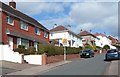
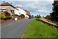
1
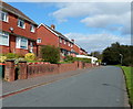
Houses near the top end of Vancouver Drive, Newport
There are houses on only one side of the road in this part of Vancouver Drive.
The opposite side of the road is sloping ground leading down to a recreation area and nature reserve.
Image: © Jaggery
Taken: 29 Sep 2012
0.01 miles
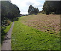
2
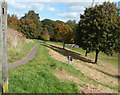
Newport: path from Vancouver Drive to a recreation area and nature reserve
This end of the path is about 200 metres south of the Canberra Crescent junction.
Image: © Jaggery
Taken: 29 Sep 2012
0.04 miles
3
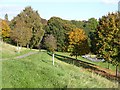
Coed Melyn Park, Glasllwch
This is on the route of the Sirhowy Valley Walk.
Image: © Robin Drayton
Taken: 19 Oct 2007
0.04 miles
4
No horse riding, Vancouver Drive, Newport
On the right, a white on dark green sign at the edge of a slope leading down to a recreation area and nature reserve shows NO HORSE RIDING.
Image: © Jaggery
Taken: 29 Sep 2012
0.05 miles
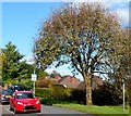
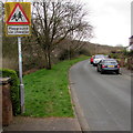
5
Approaching a play area, Vancouver Drive, Newport
A view NE up Vancouver Drive. The triangular sign is used to warn drivers of the likelihood of children in the area. It is often used on the approach to a school. Here the text is Playground.
Image: © Jaggery
Taken: 29 Sep 2012
0.05 miles
6
Warning sign - Playground/Lle chwarae, Vancouver Drive, Newport
The bilingual (English/Welsh) sign faces the Canberra Crescent junction.
Image: © Jaggery
Taken: 17 Mar 2017
0.05 miles
7
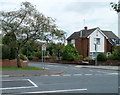
Southern arm of Canberra Crescent, Newport
Canberra Crescent forms a loop around the eastern side of Melbourne Way. This is the start of the southern part of the loop, viewed across Melbourne Way.
Image: © Jaggery
Taken: 25 Jul 2010
0.05 miles
8
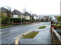
Start of 20mph speed limit, Melbourne Way, Newport
On the approach to Glasllwch Primary School, http://www.geograph.org.uk/photo/1982912 the speed limit on Melbourne Way reduces from 30mph to 20mph.
Image: © Jaggery
Taken: 18 Nov 2010
0.05 miles
9
Edge of a recreation area and nature reserve, Vancouver Drive, Newport
The camera is near the end of the houses on this side of Vancouver Drive.
Ahead is sloping land leading down to a recreation area and nature conservation area.
Image: © Jaggery
Taken: 29 Sep 2012
0.06 miles
10
Path through a nature reserve and recreation area near Vancouver Drive, Newport
The path is through a Nature Conservation Area, in the valley of a brook named Nant Coch.
Ahead is a children's play area. Vancouver Drive is at the top of the bank on the right.
Image: © Jaggery
Taken: 29 Sep 2012
0.06 miles