IMAGES TAKEN NEAR TO
Bassaleg Road, NEWPORT, NP20 3PX
Introduction
This page details the photographs taken nearby to Bassaleg Road, NP20 3PX by members of the Geograph project.
The Geograph project started in 2005 with the aim of publishing, organising and preserving representative images for every square kilometre of Great Britain, Ireland and the Isle of Man.

There are currently over 7.5m images from over14,400 individuals and you can help contribute to the project by visiting https://www.geograph.org.uk
Image Map
Images are licensed for reuse under creativecommons.org/licenses/by-sa/2.0
Notes
- Clicking on the map will re-center to the selected point.
- The higher the marker number, the further away the image location is from the centre of the postcode.
Image Listing (112 Images Found)
Images are licensed for reuse under creativecommons.org/licenses/by-sa/2.0
Image
Details
Distance
1
Dead end road west of Western Avenue, Newport
The road ahead ends at a stone wall at the edge of the M4 motorway.
Image: © Jaggery
Taken: 17 Mar 2017
0.02 miles
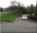
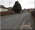
2

Southern end of Western Avenue, Newport
Looking north along Western Avenue from near the Bassaleg Road junction.
No vehicles heavier than 7.5 tonnes ahead, except for access.
Image: © Jaggery
Taken: 17 Mar 2017
0.02 miles
3
Newport : Bassaleg Road houses viewed from woodland
The houses are on the corner of Bassaleg Road and Western Avenue. Viewed from the edge of woodland on the north side of Gaer Fort.
Image: © Jaggery
Taken: 21 Jul 2011
0.02 miles
4
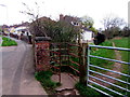
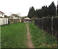
Kissing gate to a brookside track, Newport
Rusty in March 2017, the kissing gate on the east side of Western Avenue leads to a track on a bank of the brook named Nant Coch.
Image: © Jaggery
Taken: 17 Mar 2017
0.03 miles
5
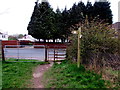
Western Avenue gates, Newport
A 7-bar gate, a kissing gate and a wooden signpost are at the Western Avenue end of a brookside track. http://www.geograph.org.uk/photo/5315067
Image: © Jaggery
Taken: 17 Mar 2017
0.03 miles
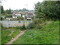
6
Brookside track towards Western Avenue, Newport
A track along a bank of a brook named Nant Coch ends ahead. http://www.geograph.org.uk/photo/5315062 The brook is behind the fence.
Image: © Jaggery
Taken: 17 Mar 2017
0.03 miles
7
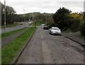
North along Western Avenue, Newport
Western Avenue extends for nearly 800 metres from Bassaleg Road (behind the camera) to the B4591.
Image: © Jaggery
Taken: 17 Mar 2017
0.03 miles
8
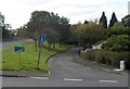
Side road alongside Bassaleg Road, Newport
Old maps shows that what is now a side road used to be the route of Bassaleg Road, now on the left.
The road realignment probably occurred in the 1960s, during the construction of the nearby M4 motorway.
Image: © Jaggery
Taken: 17 Mar 2017
0.03 miles
9
Former route of Bassaleg Road, Newport
Viewed across Western Avenue. Now a no through road ending at the edge of the M4 motorway,
this was formerly the route of Bassaleg Road, which was realigned a few metres to the left when the motorway was built in this area in the 1960s.
Image: © Jaggery
Taken: 29 Sep 2012
0.04 miles
10
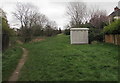
Western Avenue electricity substation, Newport
Set back 30 metres from the east side of Western Avenue, the grey cabinet is a
Western Power Distribution electricity substation. Its identifier is S/S 536371.
Image: © Jaggery
Taken: 17 Mar 2017
0.04 miles