IMAGES TAKEN NEAR TO
Gaer Park Avenue, NEWPORT, NP20 3NH
Introduction
This page details the photographs taken nearby to Gaer Park Avenue, NP20 3NH by members of the Geograph project.
The Geograph project started in 2005 with the aim of publishing, organising and preserving representative images for every square kilometre of Great Britain, Ireland and the Isle of Man.

There are currently over 7.5m images from over14,400 individuals and you can help contribute to the project by visiting https://www.geograph.org.uk
Image Map
Images are licensed for reuse under creativecommons.org/licenses/by-sa/2.0
Notes
- Clicking on the map will re-center to the selected point.
- The higher the marker number, the further away the image location is from the centre of the postcode.
Image Listing (200 Images Found)
Images are licensed for reuse under creativecommons.org/licenses/by-sa/2.0
Image
Details
Distance
1
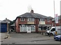
Two shops, Bassaleg Road, Newport
Close to Gaer Park post office http://www.geograph.org.uk/photo/1710715 are :
On the left, Shine hairdressers.
On the right, George's Fish Bar.
Image: © Jaggery
Taken: 14 Feb 2010
0.02 miles
2
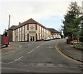
Gaer Christian Centre, Newport
Gaer Christian Centre is a large, triangular-shaped building on the corner of Highfield Road and Gaer Park Drive.
Image: © Jaggery
Taken: 14 Feb 2010
0.02 miles
3
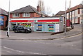
Spar, Bassaleg Road, Newport
Located on the corner of Bassaleg Road and Gaer Park Road.
Part of Gaer Christian Centre can be set in the top right of the photo. http://www.geograph.org.uk/photo/1710743
Image: © Jaggery
Taken: 14 Feb 2010
0.02 miles
4
Gaer Park Club and Institute, Newport
Viewed from the corner of Gaer Park Road. The club is located in a long, narrow building (about 40 metres by 7 metres) extending from Gaer Park Drive to Highfield Road.
Image: © Jaggery
Taken: 10 Nov 2010
0.02 miles
5
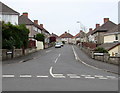
West along Gaer Park Avenue, Newport
Viewed across Gaer Park Drive.
Image: © Jaggery
Taken: 6 May 2016
0.02 miles
6
Gaer Park Road, Newport
Gaer Park Road ascends from Gaer Park Drive towards Gaer Park Hill.
Buzzy Bees nursery http://www.geograph.org.uk/photo/2153430 is on the left.
Image: © Jaggery
Taken: 6 May 2016
0.04 miles
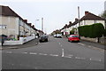
7
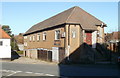
Gaer Park Avenue houses, Newport
Houses on the NW side on the avenue, viewed from the corner of Gaer Park Hill.
Image: © Jaggery
Taken: 10 Nov 2010
0.04 miles
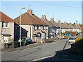
8
Gaer Park Lane, Newport
Houses on the NW side of Gaer Park Lane, viewed from the corner of Gaer Park Hill.
The bus in the distance is on Bassaleg Road.
Image: © Jaggery
Taken: 10 Nov 2010
0.04 miles
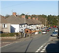
9
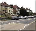
Houses and cars, Bassaleg Road, Newport
Set above the south side of Bassaleg Road, west of the Gaer Park Drive junction,
the houses face the perimeter wall of St Woolos Cemetery.
Image: © Jaggery
Taken: 19 Mar 2016
0.05 miles
10
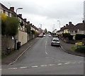
Gaer Park Lane, Newport
Gaer Park Lane ascends from Bassaleg Road into the Gaer area of Newport.
Image: © Jaggery
Taken: 17 Mar 2017
0.05 miles