IMAGES TAKEN NEAR TO
Bassaleg Road, NEWPORT, NP20 3NA
Introduction
This page details the photographs taken nearby to Bassaleg Road, NP20 3NA by members of the Geograph project.
The Geograph project started in 2005 with the aim of publishing, organising and preserving representative images for every square kilometre of Great Britain, Ireland and the Isle of Man.

There are currently over 7.5m images from over14,400 individuals and you can help contribute to the project by visiting https://www.geograph.org.uk
Image Map
Images are licensed for reuse under creativecommons.org/licenses/by-sa/2.0
Notes
- Clicking on the map will re-center to the selected point.
- The higher the marker number, the further away the image location is from the centre of the postcode.
Image Listing (240 Images Found)
Images are licensed for reuse under creativecommons.org/licenses/by-sa/2.0
Image
Details
Distance
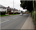
1
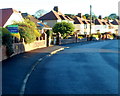
SW end of Burnfort Road, Newport
Houses on the north side of the road, viewed from the Highfield Road end.
Image: © Jaggery
Taken: 6 Oct 2012
0.03 miles
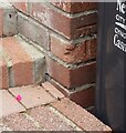
2
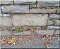
Ordnance Survey Cut Mark
This OS cut mark can be found on the cemetery wall on Bassaleg Road. It marks a point 64.470m above mean sea level.
Image: © Adrian Dust
Taken: 2 Aug 2021
0.04 miles
3

St Woolos Cemetery, Newport
A view north eastwards from a small pedestrian entrance on Bassaleg Road.
A cold frosty morning.
Image: © Robin Drayton
Taken: 9 Dec 2022
0.04 miles
4
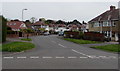
Burnfort Road, Newport
Burnfort Road heads NE towards Melfort Road.
This junction is where Highfield Road on the left becomes Gaer Road on the right.
Image: © Jaggery
Taken: 6 May 2016
0.05 miles
5
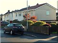
Steel-framed houses, Burnfort Road, Newport
6 of the 29 houses in Burnfort Road are steel-framed, in contrast to the rest of the houses,
such as these http://www.geograph.org.uk/photo/3166309 on the opposite side of the road.
Image: © Jaggery
Taken: 6 Oct 2012
0.05 miles
6
Ordnance Survey Cut Mark
This OS cut mark can be found on No83 Bassaleg Road. It marks a point 73.460m above mean sea level.
Image: © Adrian Dust
Taken: 2 Aug 2021
0.05 miles
7
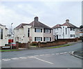
Stelvio Park Drive houses, Newport
Viewed from the corner of Stelvio Park Avenue.
Image: © Jaggery
Taken: 22 Nov 2010
0.06 miles
8
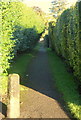
Path from Burnfort Road to Bassaleg Road, Newport
The 110 metre long path gives pedestrians a short cut to
Gaer Park post office, http://www.geograph.org.uk/photo/3154149 which is located
a few metres from the Bassaleg Road end of the path.
Image: © Jaggery
Taken: 6 Oct 2012
0.06 miles
9
Bassaleg Road houses, Newport
The houses are opposite the southern perimeter wall of St Woolos Cemetery.
Image: © Jaggery
Taken: 19 Mar 2019
0.06 miles
10
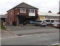
A Touch of Spice in Newport
Indian cuisine takeaway at 113 Bassaleg Road, viewed in March 2016.
Formerly a post office. http://www.geograph.org.uk/photo/3882730
Image: © Jaggery
Taken: 19 Mar 2016
0.06 miles