IMAGES TAKEN NEAR TO
Jane Austen Close, NEWPORT, NP20 3LL
Introduction
This page details the photographs taken nearby to Jane Austen Close, NP20 3LL by members of the Geograph project.
The Geograph project started in 2005 with the aim of publishing, organising and preserving representative images for every square kilometre of Great Britain, Ireland and the Isle of Man.

There are currently over 7.5m images from over14,400 individuals and you can help contribute to the project by visiting https://www.geograph.org.uk
Image Map
Images are licensed for reuse under creativecommons.org/licenses/by-sa/2.0
Notes
- Clicking on the map will re-center to the selected point.
- The higher the marker number, the further away the image location is from the centre of the postcode.
Image Listing (158 Images Found)
Images are licensed for reuse under creativecommons.org/licenses/by-sa/2.0
Image
Details
Distance
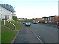
1
Maugham Close, Gaer, Newport
Viewed across Morton Way. There are 7 houses on Maugham Close, all on one side of the street. The houses face the rear of Shakespeare Crescent houses.
Image: © Jaggery
Taken: 19 Jul 2011
0.04 miles
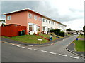
2
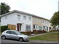
Jane Austen Close, Gaer, Newport
Housing on the north side of Jane Austen Close. There are no houses on the other side of the close.
Image: © Jaggery
Taken: 12 Nov 2009
0.04 miles
3
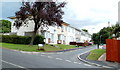
Ruskin Rise, Gaer, Newport
Ruskin Rise climbs away from Shakespeare Crescent.
Image: © Jaggery
Taken: 12 Nov 2009
0.04 miles
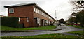
4
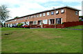
Jane Austen Close, Gaer, Newport
The view west from Morton Way. Jane Austen Close is a row of ten houses, all on one side of the street.
Image: © Jaggery
Taken: 19 Jul 2011
0.04 miles
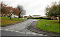
5
Priestley Close, Gaer, Newport
Viewed across Morton Way. There are 7 houses on Priestley Close, a short cul-de-sac. In common with several nearby streets, the houses are all on one side of the road. The other side is the rear of properties in the next street, Maugham Close.
Image: © Jaggery
Taken: 19 Jul 2011
0.04 miles
6
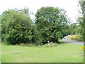
Contaminated water - keep clear, Masefield Vale, Gaer, Newport
Viewed from the corner of Shakespeare Crescent. At first glance, the trees on the side of Masefield Vale suggest a pleasant 'green lung' in the middle of the Gaer housing estate. But a notice warns
CONTAMINATED WATER - KEEP CLEAR. The water is in a small brook, shown on the Ordnance Survey map as an 'issue', draining the higher ground on the west side of Masefield Vale. I do not know when or how the water was contaminated.
Image: © Jaggery
Taken: 19 Jul 2011
0.04 miles
7
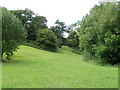
Greenery in the middle of the Gaer, Newport
Trees and grass provide a 'green lung' in the middle of the Gaer housing estate, between Masefield Vale and Dickens Drive. Viewed from near the corner of Shakespeare Crescent and Masefield Vale.
Image: © Jaggery
Taken: 19 Jul 2011
0.05 miles
8

Gaer Estate Award for Merit
http://www.geograph.org.uk/photo/621751
Image: © Robin Drayton
Taken: 6 Sep 2007
0.07 miles
9
Vanbrugh Gardens, Gaer Estate
The Gaer estate was one of the first estates built in Newport after the Second World War. All of the streets are named after writers. A Festival of Britain award was received for the design of the estate and the plaque is displayed on the end house. http://www.geograph.org.uk/photo/621755
Image: © Robin Drayton
Taken: 6 Sep 2007
0.07 miles