IMAGES TAKEN NEAR TO
Dickens Drive, NEWPORT, NP20 3JN
Introduction
This page details the photographs taken nearby to Dickens Drive, NP20 3JN by members of the Geograph project.
The Geograph project started in 2005 with the aim of publishing, organising and preserving representative images for every square kilometre of Great Britain, Ireland and the Isle of Man.

There are currently over 7.5m images from over14,400 individuals and you can help contribute to the project by visiting https://www.geograph.org.uk
Image Map
Images are licensed for reuse under creativecommons.org/licenses/by-sa/2.0
Notes
- Clicking on the map will re-center to the selected point.
- The higher the marker number, the further away the image location is from the centre of the postcode.
Image Listing (153 Images Found)
Images are licensed for reuse under creativecommons.org/licenses/by-sa/2.0
Image
Details
Distance
1
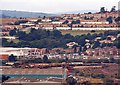
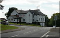
View towards the Gaer Estate (1)
Taken in 1996 from Newport Transporter Bridge.
Image: © Robin Drayton
Taken: Unknown
0.01 miles
2
A reverse crescent of dwellings, Gaer, Newport
Dickens Drive looking towards Hillview flats http://www.geograph.org.uk/photo/4492593 .
Image: © Robin Drayton
Taken: 26 Apr 2018
0.02 miles
3
Kipling Hill, Gaer, Newport
Kipling Hill climbs away from Dickens Drive.
Image: © Jaggery
Taken: 12 Feb 2010
0.04 miles
4
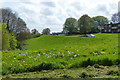
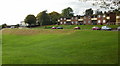
Springtime on the Gaer Estate, Newport
This estate was built on a hilly area on the western edge of Newport. As can be seen in this view, terraces were created to accommodate a number of the roads.
It was one of the first estates built in Newport after the Second World War. All of the streets are named after writers. A Festival of Britain award was received for the design of the estate and a plaque commemorating this is displayed on one of the houses http://www.geograph.org.uk/photo/621751 .
Dandelions and cuckooflowers http://www.geograph.org.uk/photo/5757011 are in the foreground.
The grass here has been left unmown as part of Newport's Bee Friendly initiative.
Image: © Robin Drayton
Taken: 26 Apr 2018
0.07 miles
5
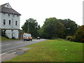
The Gaer Inn, Newport
At 37 Gaer Road. To the right of the inn, Masefield Vale descends towards the lower end of Shakespeare Crescent.
Image: © Jaggery
Taken: 1 Oct 2009
0.08 miles
6
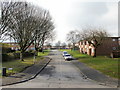
Dickens Drive, Gaer, Newport
Dickens Drive heading away from the Gaer shops. On the east side of Dickens Drive, the ground slopes steeply downwards, which accounts for the absence of houses on this side throughout its length.
Image: © Jaggery
Taken: 1 Oct 2009
0.08 miles
7
Masefield Vale, Gaer , Newport
Masefield Vale descending from the Gaer Inn towards Shakespeare Crescent.
Image: © Jaggery
Taken: 1 Oct 2009
0.08 miles
8
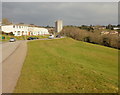
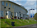
Steep slope on the east side of Dickens Drive, Gaer, Newport
For three-quarters of its length, there are no houses on the east side of Dickens Drive because the land drops away steeply towards Masefield Vale. Only at its western end, http://www.geograph.org.uk/photo/1706510 beyond Ruskin Rise, are there houses on both sides.
The tall building in the background is Hillview. http://www.geograph.org.uk/photo/1515795
Image: © Jaggery
Taken: 12 Feb 2010
0.08 miles
9
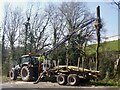
Tree felling, Masefield Vale, Gaer, Newport
Tree clearance due to ash dieback disease.
Image: © Robin Drayton
Taken: 23 Mar 2022
0.09 miles
10
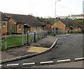
Drinkwater Close, Gaer, Newport
Bungalows on the south side of the Close, viewed from Drinkwater Gardens.
For over 50 years, until the early years of the 21st century, there were dozens of prefabs (prefabricated bungalows) in this part of the Gaer Estate. They were erected to meet the severe housing shortage in Newport after the Second World War. Modern bungalows, such as those seen here, replaced the prefabs.
Image: © Jaggery
Taken: 3 Dec 2009
0.09 miles