IMAGES TAKEN NEAR TO
Masefield Vale, NEWPORT, NP20 3HA
Introduction
This page details the photographs taken nearby to Masefield Vale, NP20 3HA by members of the Geograph project.
The Geograph project started in 2005 with the aim of publishing, organising and preserving representative images for every square kilometre of Great Britain, Ireland and the Isle of Man.

There are currently over 7.5m images from over14,400 individuals and you can help contribute to the project by visiting https://www.geograph.org.uk
Image Map
Images are licensed for reuse under creativecommons.org/licenses/by-sa/2.0
Notes
- Clicking on the map will re-center to the selected point.
- The higher the marker number, the further away the image location is from the centre of the postcode.
Image Listing (234 Images Found)
Images are licensed for reuse under creativecommons.org/licenses/by-sa/2.0
Image
Details
Distance
1
Evening view over Newport
The setting sun shining through a gap in the predominately dark clouds gave this short lived dramatic lighting.
See http://www.geograph.org.uk/photo/2953152 for a similar view but with more usual lighting.
The historic Transporter Bridge http://www.geograph.org.uk/photo/3257047 is at the upper left.
Taken from Drinkwater Gardens in the Gaer area of Newport.
Image: © Robin Drayton
Taken: 10 Mar 2016
0.01 miles
2
![Installation of Solar Photovoltaic Panels [2]](https://s2.geograph.org.uk/geophotos/02/69/35/2693574_926bbea9_120x120.jpg)
Installation of Solar Photovoltaic Panels [2]
These bungalows are part of the housing stock of Newport City Homes a not-for-profit Registered Social Landlord.
Image: © Robin Drayton
Taken: 12 Nov 2011
0.02 miles
3
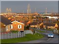
Eastern end of Masefield Vale, Gaer, Newport
Viewed from near the left turn into Drinkwater Gardens, http://www.geograph.org.uk/photo/2512865 looking towards the junction with Gaer Road.
Image: © Jaggery
Taken: 19 Jul 2011
0.02 miles
4
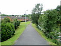
Footpath into Gaer Vale, Newport
Viewed from Gaer Road. The footpath runs through the northern edge of Gaer Vale.
On the right is a single-track railway line. http://www.geograph.org.uk/photo/2512880
Image: © Jaggery
Taken: 19 Jul 2011
0.02 miles
5
![Installation of Solar Photovoltaic Panels [1]](https://s1.geograph.org.uk/geophotos/02/69/35/2693569_946743e0_120x120.jpg)
Installation of Solar Photovoltaic Panels [1]
These bungalows are part of the housing stock of Newport City Homes a not-for-profit Registered Social Landlord.
Image: © Robin Drayton
Taken: 12 Nov 2011
0.02 miles
7
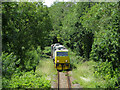
MPV near Gaer Tunnel
A Multi-purpose vehicle (MPV) pair - Nos. DR 98962 + DR 98912 - approaches Gaer Tunnel on a weedspray working. The train worked from Margam to Margam via the branch to Machen, Newport (seen here) and the Ebbw Vale branch.
Image: © Gareth James
Taken: 26 Jun 2022
0.05 miles
8
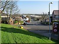
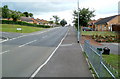
Gaer Road, Newport
The view down Gaer Road towards the junction with Cardiff Road at the bottom of the hill.
The present day Gaer Road follows the route of the original farm track from the lodge on Cardiff Road http://www.geograph.org.uk/photo/687505 to Gaer Fach farmhouse (now the Gaer Inn http://www.geograph.org.uk/photo/537653 ).
Part of this route, being rather steep, remains as a footpath http://www.geograph.org.uk/photo/2364139 .
Image: © Robin Drayton
Taken: 23 Mar 2011
0.05 miles
9
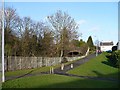
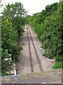
Railway tunnel entrance, Gaer Road
This single line track is currently only used for goods traffic.
It is planned to use it for the proposed passenger service between Newport and Ebbw Vale.
(The above was written in 2009. As of 2016 this service has not materialised.)
Image: © Robin Drayton
Taken: 22 Jan 2009
0.06 miles
10
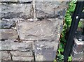
Ordnance Survey Cut Mark
This OS cut mark can be found on the SW parapet of the railway bridge. It marks a point 24.467m above mean sea level.
Image: © Adrian Dust
Taken: 2 Aug 2021
0.06 miles