IMAGES TAKEN NEAR TO
Drinkwater Close, NEWPORT, NP20 3GL
Introduction
This page details the photographs taken nearby to Drinkwater Close, NP20 3GL by members of the Geograph project.
The Geograph project started in 2005 with the aim of publishing, organising and preserving representative images for every square kilometre of Great Britain, Ireland and the Isle of Man.

There are currently over 7.5m images from over14,400 individuals and you can help contribute to the project by visiting https://www.geograph.org.uk
Image Map
Images are licensed for reuse under creativecommons.org/licenses/by-sa/2.0
Notes
- Clicking on the map will re-center to the selected point.
- The higher the marker number, the further away the image location is from the centre of the postcode.
Image Listing (162 Images Found)
Images are licensed for reuse under creativecommons.org/licenses/by-sa/2.0
Image
Details
Distance
1
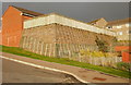
Retaining wall, Drinkwater Gardens, Gaer, Newport
On the east side of the steeply-inclined Drinkwater Gardens, http://www.geograph.org.uk/photo/1606201 a retaining wall encloses the garden of the adjoining house.
Image: © Jaggery
Taken: 3 Dec 2009
0.03 miles
2
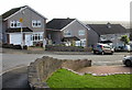
Lansdowne Road, Newport
Houses on the east side of Lansdowne Road, viewed from Gaer Road.
Image: © Jaggery
Taken: 3 Dec 2009
0.03 miles
3
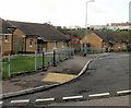
Drinkwater Close, Gaer, Newport
Bungalows on the south side of the Close, viewed from Drinkwater Gardens.
For over 50 years, until the early years of the 21st century, there were dozens of prefabs (prefabricated bungalows) in this part of the Gaer Estate. They were erected to meet the severe housing shortage in Newport after the Second World War. Modern bungalows, such as those seen here, replaced the prefabs.
Image: © Jaggery
Taken: 3 Dec 2009
0.04 miles
4
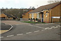
Drinkwater Rise, Gaer, Newport
Bungalows on Drinkwater Rise, viewed from Drinkwater Gardens.
For over 50 years, until the early years of the 21st century, there were dozens of prefabs (prefabricated bungalows) in this part of the Gaer Estate. They were erected to meet the severe housing shortage in Newport after the Second World War. Modern bungalows, such as those seen here, replaced the prefabs.
Image: © Jaggery
Taken: 3 Dec 2009
0.04 miles
5
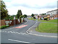
Drinkwater View, Gaer, Newport
Bungalows on Drinkwater View, from Drinkwater Gardens.
For over 50 years, until the early years of the 21st century, there were dozens of prefabs (prefabricated bungalows) in this part of the Gaer Estate. They were erected to meet the severe housing shortage in Newport after the Second World War. Modern bungalows, such as those seen here, replaced the prefabs.
Image: © Jaggery
Taken: 3 Dec 2009
0.04 miles
6
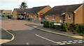
Drinkwater Gardens, Gaer, Newport
Viewed from the corner of Masefield Vale. http://www.geograph.org.uk/photo/2512856 The most obvious change from this view http://www.geograph.org.uk/photo/1606182 taken in December 2009, is the introduction of a 20mph maximum speed zone.
Image: © Jaggery
Taken: 19 Jul 2011
0.04 miles
7
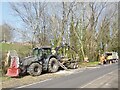
Tree felling, Masefield Vale, Gaer, Newport
Tree clearance due to ash dieback disease.
Image: © Robin Drayton
Taken: 23 Mar 2022
0.04 miles
8
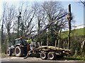
Tree felling, Masefield Vale, Gaer, Newport
Tree clearance due to ash dieback disease.
Image: © Robin Drayton
Taken: 23 Mar 2022
0.04 miles
9
![The Gaer Inn [2]](https://s1.geograph.org.uk/geophotos/01/13/60/1136017_9d742912_120x120.jpg)
The Gaer Inn [2]
For a closer view see http://www.geograph.org.uk/photo/537653 .
The Gaer Junior School is behind the inn.
Image: © Robin Drayton
Taken: 23 Dec 2008
0.07 miles
10
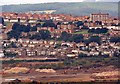
View towards the Gaer Estate (2)
Taken in 1996 from Newport Transporter Bridge.
Image: © Robin Drayton
Taken: Unknown
0.07 miles