IMAGES TAKEN NEAR TO
Cae Perllan Road, NEWPORT, NP20 3FX
Introduction
This page details the photographs taken nearby to Cae Perllan Road, NP20 3FX by members of the Geograph project.
The Geograph project started in 2005 with the aim of publishing, organising and preserving representative images for every square kilometre of Great Britain, Ireland and the Isle of Man.

There are currently over 7.5m images from over14,400 individuals and you can help contribute to the project by visiting https://www.geograph.org.uk
Image Map
Images are licensed for reuse under creativecommons.org/licenses/by-sa/2.0
Notes
- Clicking on the map will re-center to the selected point.
- The higher the marker number, the further away the image location is from the centre of the postcode.
Image Listing (261 Images Found)
Images are licensed for reuse under creativecommons.org/licenses/by-sa/2.0
Image
Details
Distance
1
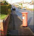
Shrunken George VI postbox, Cae Perllan Road, Newport
From a distance, I noticed something odd about this George VI postbox on the west side of Cae Perllan Road, between Byron Road and New Pastures. On close inspection, I saw that it was about a foot shorter than the usual height for a postbox. If it sinks much more, the black base will disappear and the door won't open!
Image: © Jaggery
Taken: 3 Dec 2009
0.03 miles
2
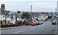
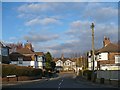
The view down Cae Perllan Road, Newport
After a steep descent from Stow Park Circle, Cae Perllan Road approaches level ground near its southern end at the junction with Cae Brynton Road.
Image: © Jaggery
Taken: 22 Nov 2010
0.03 miles
3
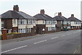
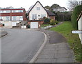
Houses at the flat southern end of Cae Perllan Road, Newport
The flatness of the land near the junction with Cae Brynton Road contrasts with the steep slope along most of Cae Perllan Road, as shown by this view. http://www.geograph.org.uk/photo/2173716
Image: © Jaggery
Taken: 22 Nov 2010
0.03 miles
4
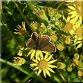
Brown Argus butterfly on Ragwort
This is the same butterfly as shown here https://www.geograph.org.uk/photo/7548288 .
Image: © Robin Drayton
Taken: 21 Jul 2023
0.05 miles
5
Oaks Close
Named after The Oaks, a detached house that existed nearby before development in the 1930s.
Image: © Robin Drayton
Taken: 1 Dec 2008
0.06 miles
6

Gatekeeper butterfly on Corn Marigold
This is a female Gatekeeper.
Corn Marigold is an annual plant of the daisy family often found in arable farmland.
Due to its widespread decline, Corn Marigold is classified as ‘Vulnerable’.
It is often included in wildflower seed mixes which was the origin of this plant.
Image: © Robin Drayton
Taken: 14 Aug 2021
0.06 miles
7

Orange on orange
A gatekeeper butterfly resting on montbretia.
There has been a profusion of gatekeepers this year (2014).
Image: © Robin Drayton
Taken: 1 Aug 2014
0.07 miles
8
Eastern end of Rupert Brooke Drive, Newport
Viewed across Byron Road.
Image: © Jaggery
Taken: 22 Nov 2010
0.07 miles
9
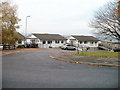
Distinctive house, New Pastures, Newport
A house with an Alpine style steeply-sloping roof is distinctly different from the other houses in New Pastures. http://www.geograph.org.uk/photo/2173737
Image: © Jaggery
Taken: 22 Nov 2010
0.07 miles
10
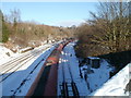
Murco train passes through Gaer Junction, Newport
A long train of 100-ton Murco wagons passes through Gaer Junction on the climb towards Hillfield tunnels. http://www.geograph.org.uk/photo/1441421
Murco Petroleum Ltd refines oil and has a network of petrol stations in the UK. http://www.geograph.org.uk/photo/1652413 Murco owns and operates four refinery terminals in the UK which receive oil by rail. They are located at Bedworth (Warwickshire), Theale (Berkshire), Westerleigh (South Gloucestershire) and Milford Haven (Pembrokeshire). The Milford Haven facility includes a marine terminal.
Image: © Jaggery
Taken: 24 Dec 2010
0.07 miles