IMAGES TAKEN NEAR TO
Cae Perllan Road, NEWPORT, NP20 3FU
Introduction
This page details the photographs taken nearby to Cae Perllan Road, NP20 3FU by members of the Geograph project.
The Geograph project started in 2005 with the aim of publishing, organising and preserving representative images for every square kilometre of Great Britain, Ireland and the Isle of Man.

There are currently over 7.5m images from over14,400 individuals and you can help contribute to the project by visiting https://www.geograph.org.uk
Image Map
Images are licensed for reuse under creativecommons.org/licenses/by-sa/2.0
Notes
- Clicking on the map will re-center to the selected point.
- The higher the marker number, the further away the image location is from the centre of the postcode.
Image Listing (251 Images Found)
Images are licensed for reuse under creativecommons.org/licenses/by-sa/2.0
Image
Details
Distance
1
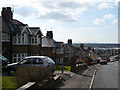
Cae Perllan Road
The Severn Estuary and the North Somerset coast can be seen in the distance.
Image: © Robin Drayton
Taken: 27 Mar 2008
0.01 miles
2
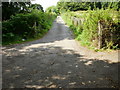
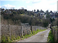
Allotment path to Cae Perllan road
After crossing the Newport to Cardiff main line, the path rises steeply towards
Cae Perllan Road. Entrances to the Cae Perllan allotments are to the left and right out of view near the bottom of the picture.
Image: © Jaggery
Taken: 13 Aug 2009
0.04 miles
3
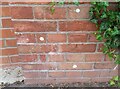
Ordnance Survey Cut Mark
This OS cut mark can be found at the junction of Cae Perllan Road & Byron Road. It marks a point 40.441m above mean sea level.
Image: © Adrian Dust
Taken: 2 Aug 2021
0.05 miles
4
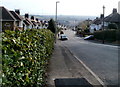
Top end of Cae Perllan Road, Newport
Viewed from the corner of Stow Park Circle. Cae Perllan Road descends towards Cae Brynton Road.
Image: © Jaggery
Taken: 6 Mar 2011
0.06 miles
5
Footpath from Cae Perllan Road
The path down to a footbridge across the railway and then up to Image
Image: © Robin Drayton
Taken: 27 Mar 2008
0.08 miles
6
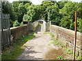
Footbridge across the main line
Behind is the path from Coldra Road allotments. The path continues across the Newport to Cardiff main railway line towards Cae Perllan allotments.
Image: © Jaggery
Taken: 13 Aug 2009
0.08 miles
7
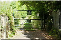
Entrance gate to Cae Perllan allotments
The sign on the gate states No Tresspassing. I resisted the temptation to leave a "No misspelt signs" sign next to it. A similar gate and sign guard a second entrance on the other side of the path. If you wish to get in to the allotments, here's how http://www.geograph.org.uk/photo/1441427
Image: © Jaggery
Taken: 13 Aug 2009
0.08 miles
8
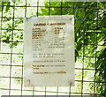
Allotment notice
Allotments are available from £14.50 a year.
Image: © Jaggery
Taken: 13 Aug 2009
0.08 miles
9
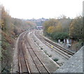
Gaer Junction, Newport
Viewed from Cardiff Road looking towards Hillfield Tunnel. http://www.geograph.org.uk/photo/1441421
This is part of the South Wales main line, between Newport and Cardiff. Trains have used this route since 1850, the year of the opening of the line by the South Wales Railway. It became a junction in 1879 when lines through a tunnel from Park Junction gave access to Newport High Street station for the Western Valley Line.
Currently the line to Park Junction (near the middle left of the view) is not suitable for passenger services, so only occasional freight trains now use that route. Until the track is improved, passengers from Newport wishing to use the reopened Ebbw Vale Railway must either travel by car or bus to Rogerstone station on the western edge of Newport, or travel by train via Cardiff. That rail journey would be about 40 kilometres long, in contrast with about 4 kilometres if a direct route to Rogerstone were available.
Image: © Jaggery
Taken: 22 Nov 2010
0.08 miles
10
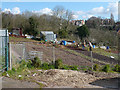
Cae Perllan Road Allotments
Situated between Cae Perllan Road and the South Wales main line railway.
Image: © Robin Drayton
Taken: 27 Mar 2008
0.08 miles