IMAGES TAKEN NEAR TO
Maesglas Road, NEWPORT, NP20 3DH
Introduction
This page details the photographs taken nearby to Maesglas Road, NP20 3DH by members of the Geograph project.
The Geograph project started in 2005 with the aim of publishing, organising and preserving representative images for every square kilometre of Great Britain, Ireland and the Isle of Man.

There are currently over 7.5m images from over14,400 individuals and you can help contribute to the project by visiting https://www.geograph.org.uk
Image Map
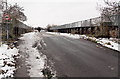
Images are licensed for reuse under creativecommons.org/licenses/by-sa/2.0
Notes
- Clicking on the map will re-center to the selected point.
- The higher the marker number, the further away the image location is from the centre of the postcode.
Image Listing (96 Images Found)
Images are licensed for reuse under creativecommons.org/licenses/by-sa/2.0
Image
Details
Distance
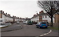
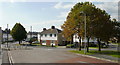
1
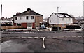
Maesglas Road and Maesglas Avenue, Newport
The house on the left side of the car is 143 Maesglas Road.
The house on the right side of the car is 130 Maesglas Avenue.
Image: © Jaggery
Taken: 25 Jan 2013
0.01 miles
2
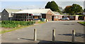
Maesglas Sports and Social Club
Maesglas Avenue, near the railway main line.
Image: © Jaggery
Taken: 16 Sep 2009
0.02 miles
3
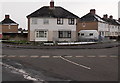
Two semis in different streets, Maesglas, Newport
The semi on the left is number 2, Maesglas Crescent.
The semi on the right is number 126, Maesglas Road.
The respective street name signs are in front of the two houses.
Image: © Jaggery
Taken: 25 Jan 2013
0.02 miles
4
Eastern end of Maesglas Road, Newport
Viewed from the edge of this http://www.geograph.org.uk/photo/3310849 bridge.
Image: © Jaggery
Taken: 25 Jan 2013
0.03 miles
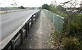
5
Road bridge across the railway, Maesglas, Newport
There is a 7.5 tonne weight limit across the bridge over the South Wales main railway line.
The bridge connects the Mendalgief area behind the camera with Maesglas ahead.
Image: © Jaggery
Taken: 25 Jan 2013
0.04 miles
6
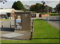
Maesglas Sewage Pumping Station
On the north side of Maesglas Avenue, close to the Sports and Social club.
Image: © Jaggery
Taken: 16 Sep 2009
0.04 miles
7
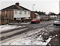
Maesglas Road, Newport
Looking WNW from Maesglas Crescent.
Image: © Jaggery
Taken: 25 Jan 2013
0.06 miles
8
Footpath on Docks Way railway bridge
North side of the bridge, looking west.
Image: © Jaggery
Taken: 16 Sep 2009
0.06 miles
9
Maesglas junctions, Newport
The view west from the approach to the railway bridge (behind camera). On the far left, Maesglas Crescent continues beyond the left edge of the photo ; Maesglas Road continues from the bridge along the left side and Maesglas Avenue is on the right.
Image: © Jaggery
Taken: 16 Sep 2009
0.06 miles
10
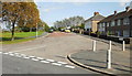
Maesglas Road
The view along the end of Maesglas Road as it approaches the railway bridge.
Image: © Jaggery
Taken: 16 Sep 2009
0.06 miles