IMAGES TAKEN NEAR TO
St. Davids Crescent, NEWPORT, NP20 3AW
Introduction
This page details the photographs taken nearby to St. Davids Crescent, NP20 3AW by members of the Geograph project.
The Geograph project started in 2005 with the aim of publishing, organising and preserving representative images for every square kilometre of Great Britain, Ireland and the Isle of Man.

There are currently over 7.5m images from over14,400 individuals and you can help contribute to the project by visiting https://www.geograph.org.uk
Image Map
Images are licensed for reuse under creativecommons.org/licenses/by-sa/2.0
Notes
- Clicking on the map will re-center to the selected point.
- The higher the marker number, the further away the image location is from the centre of the postcode.
Image Listing (275 Images Found)
Images are licensed for reuse under creativecommons.org/licenses/by-sa/2.0
Image
Details
Distance
1
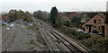
The view east from Park Junction, Gaer, Newport
The tracks head away from Park Junction towards the main line at Ebbw Junction.
7-foot (about 2 metres) high solid walls on both sides of the Park Junction footbridge are not photographer-friendly, so this view doesn't show the track, beyond the left edge of the photo, which heads towards Gaer Tunnel.
Image: © Jaggery
Taken: 12 Nov 2009
0.03 miles
2
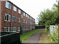
Western edge of Gaer Vale, Newport
Gaer Vale is an area of houses and flats located between Cardiff Road and a single-track railway line. The railway fence can be seen on the right.
Ahead are flats numbered 143-154. The path along the NW edge of Gaer Vale ends at the wall at the far end of the flats.
Image: © Jaggery
Taken: 23 Aug 2011
0.04 miles
3
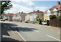
Eastern end of Park Drive, Newport
The two ends of Park Drive, about 300 metres apart, connect with Cardiff Road.
This is the eastern end of the road, viewed from the corner of Cardiff Road.
http://www.geograph.org.uk/photo/1580228 to a view of the western side of Park Drive.
Image: © Jaggery
Taken: 20 Jun 2010
0.05 miles
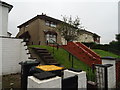
4

St Davids Crescent, Maesglas, Newport
St Davids Crescent is alongside the railway tracks heading away from Park Junction.
Image: © Jaggery
Taken: 12 Nov 2009
0.06 miles
5
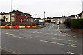
Junction of Park Drive and Cardiff Road, Newport
The two ends of Park Drive, about 300 metres apart, connect with Cardiff Road.
This is the eastern end of Park Drive, viewed across Cardiff Road.
Image: © Jaggery
Taken: 21 Dec 2016
0.07 miles
7
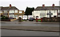
Cardiff Road houses, Maesglas, Newport
Opposite Maesglas shops. http://www.geograph.org.uk/photo/5233940
Image: © Jaggery
Taken: 21 Dec 2016
0.07 miles
8
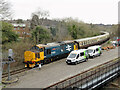
The South Wales Explorer railtour at Park Junction
Vintage Trains' South Wales Explorer railtour featured diesel class 37 No. 37403 and class 20 No. 20189 locomotives in top-and-tail formation. The tour originated at Dorridge and visited Cardiff Central via reversal at Park Junction, an empty stock move to Pengam Sidings and then Cardiff to Cwmbargoed, returning to Ninian Park and then back to Dorridge.
In this view, No. 37403 is in the lead on the approach to Park Junction near Newport.
Image: © Gareth James
Taken: 11 Mar 2023
0.07 miles
9
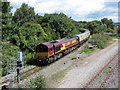
Railtour at Park Junction
UK Railtours brought a pair of class 66 locomotives, Nos. 66011 and 66116, in top-and-tail formation, to South Wales on their Valley Legend railtour. The tour visited the Ebbw Vale and Tower Colliery branches, and is seen here approaching Park Junction on the way to Ebbw Vale.
Image: © Gareth James
Taken: 30 Jul 2017
0.08 miles
10

Park Drive
Park Drive from the air showing parts of Maesglas including the Ebbw Bridge club. Photo 1977.
Image: © Shaun McGuire
Taken: Unknown
0.08 miles