IMAGES TAKEN NEAR TO
Cardiff Road, NEWPORT, NP20 3AG
Introduction
This page details the photographs taken nearby to Cardiff Road, NP20 3AG by members of the Geograph project.
The Geograph project started in 2005 with the aim of publishing, organising and preserving representative images for every square kilometre of Great Britain, Ireland and the Isle of Man.

There are currently over 7.5m images from over14,400 individuals and you can help contribute to the project by visiting https://www.geograph.org.uk
Image Map
Images are licensed for reuse under creativecommons.org/licenses/by-sa/2.0
Notes
- Clicking on the map will re-center to the selected point.
- The higher the marker number, the further away the image location is from the centre of the postcode.
Image Listing (235 Images Found)
Images are licensed for reuse under creativecommons.org/licenses/by-sa/2.0
Image
Details
Distance
1
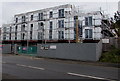
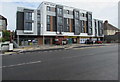
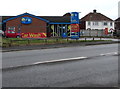
West Point Apartments, Cardiff Road, Maesglas, Newport
Under construction on August 15th 2018. An information board states that the building will contain 21 luxury 1 & 2 bedroom apartments with parking, an outdoor communal terrace and balconies. Prices from £115,000.
The site was formerly occupied by the Ebbw Bridge Club seen here https://www.geograph.org.uk/photo/1925506 in 2010.
Image: © Jaggery
Taken: 15 Aug 2018
0.00 miles
2
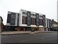
West Point, Newport
Shops with apartments over.
Image: © JThomas
Taken: 15 Oct 2019
0.00 miles
3
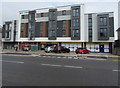
Heron Foods, West Point, Cardiff Road, Newport
Viewed on August 14th 2019. Occupying more than half of the ground floor of West Point, Heron opened its first Newport store here on July 15th 2019. The company's head office is in Melton in the East Riding of Yorkshire.
Image: © Jaggery
Taken: 14 Aug 2019
0.00 miles
4
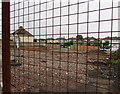
October 2017 view through an Old Cardiff Road fence, Maesglas, Newport
The demolition site was formerly occupied by Ebbw Bridge club, seen here http://www.geograph.org.uk/photo/2533809 in August 2011.
Image: © Jaggery
Taken: 11 Oct 2017
0.01 miles
5
West Point, Cardiff Road, Newport
Recently built block of apartments viewed in August 2019. Heron Foods shop https://www.geograph.org.uk/photo/6238226 is on the ground floor.
This site was formerly occupied by Ebbw Bridge Club, seen here https://www.geograph.org.uk/photo/1925506 in June 2010.
Image: © Jaggery
Taken: 14 Aug 2019
0.01 miles
6
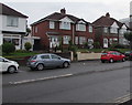
Cardiff Road semis, Maesglas, Newport
Four semi-detached houses viewed across the B4237 Cardiff Road. Codielocks hair salon is on the left.
Image: © Jaggery
Taken: 15 Aug 2018
0.01 miles
7
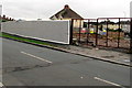
Fenced-off demolition site in Maesglas, Newport
The Old Cardiff Road side of the demolished Ebbw Bridge club viewed in October 2017.
This http://www.geograph.org.uk/photo/2533809 August 2011 photo shows the club.
Image: © Jaggery
Taken: 11 Oct 2017
0.01 miles
9
ARC Car Wash, Maesglas, Newport
Cardiff Road side of the car wash on the corner of Old Cardiff Road.
Image: © Jaggery
Taken: 15 Aug 2018
0.03 miles
10
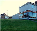
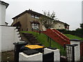
Sheppards Fish and Chips Bar, Maesglas, Newport
Set above the roadway at 205 Cardiff Road. Maesglas Road houses are in the background.
Image: © Jaggery
Taken: 25 Dec 2013
0.03 miles