IMAGES TAKEN NEAR TO
Arthur Close, NEWPORT, NP20 2NL
Introduction
This page details the photographs taken nearby to Arthur Close, NP20 2NL by members of the Geograph project.
The Geograph project started in 2005 with the aim of publishing, organising and preserving representative images for every square kilometre of Great Britain, Ireland and the Isle of Man.

There are currently over 7.5m images from over14,400 individuals and you can help contribute to the project by visiting https://www.geograph.org.uk
Image Map
Images are licensed for reuse under creativecommons.org/licenses/by-sa/2.0
Notes
- Clicking on the map will re-center to the selected point.
- The higher the marker number, the further away the image location is from the centre of the postcode.
Image Listing (217 Images Found)
Images are licensed for reuse under creativecommons.org/licenses/by-sa/2.0
Image
Details
Distance
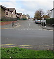
1
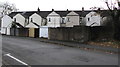
Arthur Close, Newport
Viewed from Arthur Street. Arranged along three sides of a rectangle, houses in Arthur Close were built in the early 1980s.
Image: © Jaggery
Taken: 12 Jul 2014
0.02 miles
2
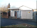
Kingdom Hall, Capel Crescent, Newport
Located behind an electricity substation on Capel Crescent. A Kingdom Hall is a place of worship used by Jehovah's Witnesses. They use the term rather than church because the biblical use of church usually refers to the congregation of people rather than a structure.
Image: © Jaggery
Taken: 15 Dec 2010
0.03 miles
3
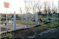
Entrance to Capel Crescent allotments, Newport
Viewed about an hour before sunset in mid-December. The allotments, on the south side of Capel Crescent, are one of 22 sites owned by Newport City Council. Residents of the city may apply to the council to rent an allotment plot, to be used for growing vegetables, flowers, etc.
Image: © Jaggery
Taken: 15 Dec 2010
0.03 miles
4
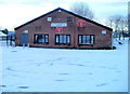
Pill Harriers Sports Club, Newport
The club faces the corner of Belle Vue Terrace and Arthur Street. It is at the NW edge of a recreation ground. In season 2010-2011, Pill Harriers RFC (Rugby Football Club) play in the Welsh Rugby Union Division Three East (also known as SWALEC Division Three East).
Image: © Jaggery
Taken: 17 Dec 2010
0.03 miles
5
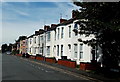
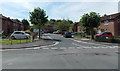
Row of houses in Arthur Street, Newport
The 50 metre long row is opposite Arthur Close. Ahead are Spring Gardens and Mendalgief Road.
Image: © Jaggery
Taken: 12 Jul 2014
0.03 miles
6
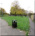
Bilingual text on a bin at the edge of a recreation ground, Pill, Newport
LITTER is on the left side, the Welsh SBWRIEL on the right side of the bin in the Pill area of Newport.
Image: © Jaggery
Taken: 29 Oct 2017
0.03 miles
7
Rear windows, Belle Vue Terrace, Newport
The backs of Arthur Street houses viewed across Belle Vue Terrace.
Image: © Jaggery
Taken: 29 Oct 2017
0.04 miles
8
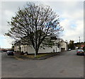
Tree at a V-junction, Pill, Newport
The V-shaped junction of Arthur Street (on the left) and Belle Vue Terrace in the Pill area of Newport.
Image: © Jaggery
Taken: 29 Oct 2017
0.04 miles
9
Arthur Street, Newport
From Mendalgief Road along Arthur Street towards Arthur Close and Belle Vue Terrace.
Image: © Jaggery
Taken: 29 Oct 2017
0.04 miles
10
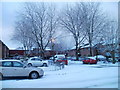
Arthur Close, Newport
Arthur Close contains 20 houses, built in the early 1980s. Viewed from Arthur Street.
Image: © Jaggery
Taken: 17 Dec 2010
0.04 miles