IMAGES TAKEN NEAR TO
Mendalgief Road, NEWPORT, NP20 2HH
Introduction
This page details the photographs taken nearby to Mendalgief Road, NP20 2HH by members of the Geograph project.
The Geograph project started in 2005 with the aim of publishing, organising and preserving representative images for every square kilometre of Great Britain, Ireland and the Isle of Man.

There are currently over 7.5m images from over14,400 individuals and you can help contribute to the project by visiting https://www.geograph.org.uk
Image Map
Images are licensed for reuse under creativecommons.org/licenses/by-sa/2.0
Notes
- Clicking on the map will re-center to the selected point.
- The higher the marker number, the further away the image location is from the centre of the postcode.
Image Listing (257 Images Found)
Images are licensed for reuse under creativecommons.org/licenses/by-sa/2.0
Image
Details
Distance
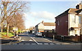
1
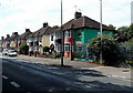
Mendalgief Road houses, Newport
More than 500 metres from the northern end of Mendalgief Road, these are the first houses on this side of the road. Behind the camera is a derelict former factory site. Part of the site fencing is on the right.
Image: © Jaggery
Taken: 12 Jul 2014
0.00 miles
2
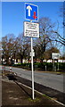
Priority over oncoming vehicles sign, Mendalgief Road, Newport
The sign text is also in Welsh.
Image: © Jaggery
Taken: 12 Feb 2020
0.00 miles
3
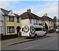
County in the Community van, Mendalgief Road, Newport
The Newport County AFC website records that (Newport) County In The Community Trust is one of 72 league clubs affiliated to the Football League Trust, delivering sporting projects and schemes for everyone in Newport, Monmouthshire and Torfaen.
It was formed in September 2013 and has endeavoured to deliver and increase participation for people from 3-83 years of age. Under the guidance of The Football League Trust, the Community team meet the key themes of Sports Participation, Health and Education, Social Inclusion and the Environment. County In The Community Trust deliver mainly football sessions, projects and schemes in and around the Newport area to engage local people and create a positive experience through Newport County AFC.
Some of the projects the Community run include the Ladies Team, Futsall Team, Walking Football Team and the "We Wear the Same Shirt" team.
Image: © Jaggery
Taken: 29 Oct 2017
0.01 miles
4
![A view across Newport from the Royal Gwent Hospital [4]](https://s2.geograph.org.uk/geophotos/01/31/93/1319358_8ac7b8dc_120x120.jpg)
A view across Newport from the Royal Gwent Hospital [4]
Looking towards Newport Docks http://www.geograph.org.uk/photo/1231953 .
Image: © Robin Drayton
Taken: 16 May 2009
0.01 miles
5
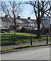
Directions sign alongside Mendalgief Road, Newport
On the approach to the right turn into Docks Way.
Pillgwenlly is usually known as Pill locally.
Image: © Jaggery
Taken: 12 Feb 2020
0.01 miles
6
Marion Street, Newport
Viewed from Mendalgief Road.
Image: © Jaggery
Taken: 30 Nov 2009
0.02 miles
7
Marion Street houses, Newport
A row of houses painted in pastel shades in the middle section of Marion Street, opposite St Michaels RC Primary School. http://www.geograph.org.uk/photo/2207653
Image: © Jaggery
Taken: 24 Dec 2010
0.02 miles
8
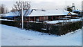
St Michaels RC Primary School, Newport
The school occupies a site between Marion Street and Baldwin Close, on the SE side of (and here viewed from) Mendalgief Community Park. The school first opened in 1899. The current buildings date from 1988. In the background, upper right corner, is the landmark Transporter Bridge. http://www.geograph.org.uk/photo/1624855
Image: © Jaggery
Taken: 24 Dec 2010
0.02 miles
9
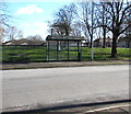
Mendalgief Road bus stop and shelter, Newport
A bench is alongside the shelter.
Image: © Jaggery
Taken: 12 Feb 2020
0.03 miles
10
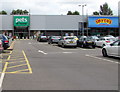
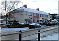
Pets at Home, Mendalgief Retail Park, Newport
Pet shop, veterinary surgery and pet grooming located in Unit 3, Mendalgief Retail Park
on the north side of Docks Way. Smyths Toys superstore http://www.geograph.org.uk/photo/5032012 is on the right.
Image: © Jaggery
Taken: 11 Jul 2016
0.04 miles