IMAGES TAKEN NEAR TO
Kirby Lane, NEWPORT, NP20 2ET
Introduction
This page details the photographs taken nearby to Kirby Lane, NP20 2ET by members of the Geograph project.
The Geograph project started in 2005 with the aim of publishing, organising and preserving representative images for every square kilometre of Great Britain, Ireland and the Isle of Man.

There are currently over 7.5m images from over14,400 individuals and you can help contribute to the project by visiting https://www.geograph.org.uk
Image Map
Images are licensed for reuse under creativecommons.org/licenses/by-sa/2.0
Notes
- Clicking on the map will re-center to the selected point.
- The higher the marker number, the further away the image location is from the centre of the postcode.
Image Listing (400 Images Found)
Images are licensed for reuse under creativecommons.org/licenses/by-sa/2.0
Image
Details
Distance
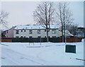
1
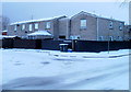
Charlotte Green, Newport
No, not the BBC radio news reader, but an area of flats and a few houses, on the south side of Alma Street.
Image: © Jaggery
Taken: 17 Dec 2010
0.00 miles
2
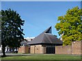
Emmanuel Evangelical Church, Newport
The Church was established in 1866 following a visit of Charles Spurgeon to Newport. A chapel was erected in Alma Street and opened in 1875, serving the congregation until 1976 when the building was demolished due to the redevelopment of the Pillgwenlly area of Newport. This building was constructed in 1977 and the name was changed from Alma Street Baptist Church to Emmanuel Evangelical Church.
Image: © Robin Drayton
Taken: 9 Aug 2007
0.06 miles
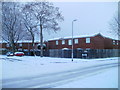
3
Rutland Place, Newport
Houses on the west side of Rutland Place, viewed from the Alma Street end.
In the distance is a small part of the Royal Gwent Hospital. http://www.geograph.org.uk/photo/527560
Image: © Jaggery
Taken: 30 May 2010
0.06 miles
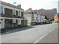
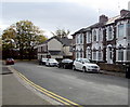
4
Kirby Lane, Newport
Housing on the corner of Kirby Lane and Alma Street. Kirby Lane contains houses and flats. The properties are numbered between 316 and 336, part of a sequence shared with nearby streets built at about the same time.
Image: © Jaggery
Taken: 17 Dec 2010
0.06 miles
5
Rutland Place houses, Newport
Opposite Emmanuel Evangelical Church. http://www.geograph.org.uk/photo/5609527
Image: © Jaggery
Taken: 29 Oct 2017
0.06 miles
6
Corner of Herbert Walk and Alma Street, Newport
Viewed across Alma Street.
Image: © Jaggery
Taken: 17 Dec 2010
0.06 miles
7
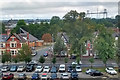
A view from the Royal Gwent Hospital, Newport (1)
Taken from level 4 of the hospital and looking across Cardiff Road at the junction with Rutland Place.
To the left of centre is Emmanuel Evangelical Church https://www.geograph.org.uk/photo/527564 .
Newport Transporter Bridge https://www.geograph.org.uk/photo/5758751 is at the upper right.
Image: © Robin Drayton
Taken: 19 Aug 2018
0.06 miles
8
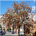
Rowan tree, Rutland Place, Newport
A bountiful crop of berries this year.
Image: © Robin Drayton
Taken: 26 Sep 2021
0.06 miles
9
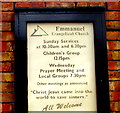
Information board on the wall of Emmanuel Evangelical Church, Newport
On the right here. http://www.geograph.org.uk/photo/5609527
Image: © Jaggery
Taken: 29 Oct 2017
0.07 miles
10
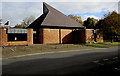
Emmanuel Evangelical Church, Rutland Place, Newport
See http://www.geograph.org.uk/photo/527564 for an earlier photo and some details.
Image: © Jaggery
Taken: 29 Oct 2017
0.07 miles