IMAGES TAKEN NEAR TO
Alma Street, NEWPORT, NP20 2EP
Introduction
This page details the photographs taken nearby to Alma Street, NP20 2EP by members of the Geograph project.
The Geograph project started in 2005 with the aim of publishing, organising and preserving representative images for every square kilometre of Great Britain, Ireland and the Isle of Man.

There are currently over 7.5m images from over14,400 individuals and you can help contribute to the project by visiting https://www.geograph.org.uk
Image Map
Images are licensed for reuse under creativecommons.org/licenses/by-sa/2.0
Notes
- Clicking on the map will re-center to the selected point.
- The higher the marker number, the further away the image location is from the centre of the postcode.
Image Listing (344 Images Found)
Images are licensed for reuse under creativecommons.org/licenses/by-sa/2.0
Image
Details
Distance
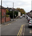
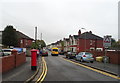
1
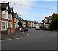
Alma Street, Newport
The southwest end of Alma Street viewed across Capel Crescent.
Image: © Jaggery
Taken: 29 Oct 2017
0.01 miles
2
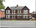
Newport Denture Laboratory
51 Cardiff Road,Newport, opposite the Royal Gwent Hospital. Underneath their name on the green plaque is written "Emergency Denture Repairs"
Image: © Jaggery
Taken: 13 Aug 2009
0.02 miles
3
Southern edge of Royal Gwent Hospital, Newport
The view NE from a footpath http://www.geograph.org.uk/photo/2209757 at the SW edge of the hospital.
Image: © Jaggery
Taken: 23 Dec 2010
0.02 miles
4
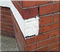
Ordnance Survey Cut Mark
This OS cut mark can be found on No51 Cardiff Road. It marks a point 12.127m above mean sea level.
Image: © Adrian Dust
Taken: 17 Jun 2018
0.04 miles
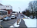
5
From one-way to two-way, Capel Crescent, Newport
One-way traffic on the camera side, two-way traffic ahead, near the Alma Street junction.
Image: © Jaggery
Taken: 29 Oct 2017
0.04 miles
6
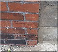
Ordnance Survey Cut Mark
This OS cut mark can be found on No134 Alma Street. It marks a point 10.287m above mean sea level.
Image: © Adrian Dust
Taken: 9 Jun 2018
0.04 miles
7
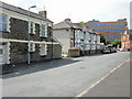
Rutland Place, Newport
Houses on the west side of Rutland Place, viewed from the Alma Street end.
In the distance is a small part of the Royal Gwent Hospital. http://www.geograph.org.uk/photo/527560
Image: © Jaggery
Taken: 30 May 2010
0.05 miles
8
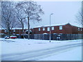
Kirby Lane, Newport
Housing on the corner of Kirby Lane and Alma Street. Kirby Lane contains houses and flats. The properties are numbered between 316 and 336, part of a sequence shared with nearby streets built at about the same time.
Image: © Jaggery
Taken: 17 Dec 2010
0.05 miles
9
Capel Crescent, Newport
Showing position of Postbox No. NP20 22.
See Image] for postbox.
Image: © JThomas
Taken: 15 Oct 2019
0.05 miles
10

Direction signs, Cardiff Road, Newport
Facing traffic heading away from the city centre on the approach to crossroads.
Image: © Jaggery
Taken: 1 Dec 2018
0.05 miles