IMAGES TAKEN NEAR TO
Dolphin Street, NEWPORT, NP20 2AS
Introduction
This page details the photographs taken nearby to Dolphin Street, NP20 2AS by members of the Geograph project.
The Geograph project started in 2005 with the aim of publishing, organising and preserving representative images for every square kilometre of Great Britain, Ireland and the Isle of Man.

There are currently over 7.5m images from over14,400 individuals and you can help contribute to the project by visiting https://www.geograph.org.uk
Image Map
Images are licensed for reuse under creativecommons.org/licenses/by-sa/2.0
Notes
- Clicking on the map will re-center to the selected point.
- The higher the marker number, the further away the image location is from the centre of the postcode.
Image Listing (557 Images Found)
Images are licensed for reuse under creativecommons.org/licenses/by-sa/2.0
Image
Details
Distance
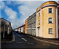
1

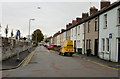
North along Duke Street, Newport
From Bolt Street along Duke Street towards Dolphin Street.
Image: © Jaggery
Taken: 24 Jun 2018
0.02 miles
2
One way traffic on Dolphin Street, Newport
A view WSW from the Lower Dock Street end, opposite Melita House and Europa House http://www.geograph.org.uk/photo/1600411
A white arrow on a blue sign, and a white arrow painted on the roadway,
indicate the direction of the one-way traffic flow in Dolphin Street.
Image: © Jaggery
Taken: 16 Mar 2013
0.02 miles
3
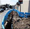
Welsh Water trench, East Market Street, Newport
Viewed over these https://www.geograph.org.uk/photo/5818990 temporary barriers in June 2018.
Image: © Jaggery
Taken: 24 Jun 2018
0.02 miles
4
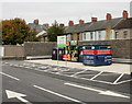
Asda recycling, Pill, Newport
The recycling containers are in pristine condition. They are located in the south east corner of the Asda superstore car park, Pill, Newport. The photo was taken 2 minutes before the store opened its doors for trading for the first time.
Image: © Jaggery
Taken: 5 Oct 2009
0.02 miles
5
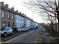
South Market Street, Newport
Houses on the south side of South Market Street, viewed from the corner of Lower Dock Street. The north side of the street was formerly the edge of the cattle market; now it is the edge of the Asda superstore.
http://www.geograph.org.uk/photo/1789261 to the view from the other end of South Market Street.
Image: © Jaggery
Taken: 30 Nov 2009
0.02 miles
6
South Market Street, Newport
The view from the corner of West Market Street.
The wall on the left is the perimeter of the Asda superstore built on the site of the former cattle market. The photo was taken on the day the superstore opened, October 5th 2009. An Asda advertising balloon can be seen at the top centre of the photo.
http://www.geograph.org.uk/photo/1600439 to a view of South Market Street from the opposite end of the street.
Image: © Jaggery
Taken: 5 Oct 2009
0.02 miles
7
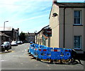
Blue temporary barriers on the corner of South Market Street and East Market Street, Newport
Welsh Water barriers enclose a trench https://www.geograph.org.uk/photo/5818991 in the road in June 2018.
Image: © Jaggery
Taken: 24 Jun 2018
0.04 miles
8
Signs and graffiti on a Pill corner, Newport
A one-way sign is on the South Market Street side of the corner. A no through road sign, hydrant sign and graffiti are on the West Market Street side in the Pill(gwenlly) area of Newport.
Image: © Jaggery
Taken: 24 Jun 2018
0.04 miles
9
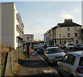
Lower Dock Street Newport approaching Octopus Bridge roundabout
The view southeastwards along Lower Dock Street. The sign is a little misleading. Octopus Bridge (so called because of the number of roads that converged on it, several but probably not eight) was demolished in the 1990s during the construction of Usk Way. In its place is the roundabout sometimes referred to as the Octopus (Bridge) roundabout.http://www.geograph.org.uk/photo/1600389
Image: © Jaggery
Taken: 27 Nov 2009
0.04 miles
10
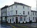
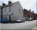
The Riverview Club, Newport
Located at the corner of Lower Dock Street and South Market Street.
Image: © Jaggery
Taken: 27 Nov 2009
0.04 miles