IMAGES TAKEN NEAR TO
Bolt Close, NEWPORT, NP20 2AJ
Introduction
This page details the photographs taken nearby to Bolt Close, NP20 2AJ by members of the Geograph project.
The Geograph project started in 2005 with the aim of publishing, organising and preserving representative images for every square kilometre of Great Britain, Ireland and the Isle of Man.

There are currently over 7.5m images from over14,400 individuals and you can help contribute to the project by visiting https://www.geograph.org.uk
Image Map
Images are licensed for reuse under creativecommons.org/licenses/by-sa/2.0
Notes
- Clicking on the map will re-center to the selected point.
- The higher the marker number, the further away the image location is from the centre of the postcode.
Image Listing (405 Images Found)
Images are licensed for reuse under creativecommons.org/licenses/by-sa/2.0
Image
Details
Distance
1

East along Bolt Street, Newport
Towards Canal Terrace and Enterprise Way.
Image: © Jaggery
Taken: 24 Jun 2018
0.02 miles
2
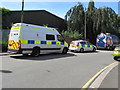
Police vehicles, Canal Terrace, Newport
Parked near Pillgwenlly Police Station. https://www.geograph.org.uk/photo/5818270
Pillgwenlly is the official name of the area of Newport usually known as Pill.
Image: © Jaggery
Taken: 24 Jun 2018
0.02 miles
3
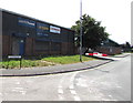
City Plumbing Supplies, Newport
The Enterprise Way side of the business set back from the corner of Canal Terrace.
Image: © Jaggery
Taken: 24 Jun 2018
0.02 miles
4

IDM Plastics, Newport
Located in Unit 1C, Enterprise Way, on the right here. https://www.geograph.org.uk/photo/5818127
Image: © Jaggery
Taken: 24 Jun 2018
0.02 miles
5
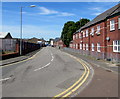
Bend at the eastern end of Bolt Street, Newport
Viewed from near the Canal Terrace/Enterprise Way junction looking west along Bolt Street towards Commercial Road.
Image: © Jaggery
Taken: 24 Jun 2018
0.03 miles
6
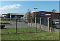
City Plumbing, Newport
Bolt Street business viewed from Usk Way.
Image: © Jaggery
Taken: 21 Sep 2014
0.03 miles
7
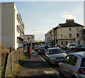
Lower Dock Street Newport approaching Octopus Bridge roundabout
The view southeastwards along Lower Dock Street. The sign is a little misleading. Octopus Bridge (so called because of the number of roads that converged on it, several but probably not eight) was demolished in the 1990s during the construction of Usk Way. In its place is the roundabout sometimes referred to as the Octopus (Bridge) roundabout.http://www.geograph.org.uk/photo/1600389
Image: © Jaggery
Taken: 27 Nov 2009
0.03 miles
8
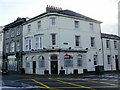
The Riverview Club, Newport
Located at the corner of Lower Dock Street and South Market Street.
Image: © Jaggery
Taken: 27 Nov 2009
0.03 miles
9
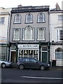
Restbite Cafe, Newport
90 Lower Dock Street, next door to the Riverview Club http://www.geograph.org.uk/photo/1599740
Image: © Jaggery
Taken: 27 Nov 2009
0.03 miles
10
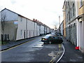
Dolphin Street, Newport
Looking along Dolphin Street from near the western edge of the Octopus (Bridge) roundabout. http://www.geograph.org.uk/photo/1789403 to the view from the other end of the street.
Image: © Jaggery
Taken: 27 Nov 2009
0.03 miles