IMAGES TAKEN NEAR TO
Talbot Lane, NEWPORT, NP20 1JW
Introduction
This page details the photographs taken nearby to Talbot Lane, NP20 1JW by members of the Geograph project.
The Geograph project started in 2005 with the aim of publishing, organising and preserving representative images for every square kilometre of Great Britain, Ireland and the Isle of Man.

There are currently over 7.5m images from over14,400 individuals and you can help contribute to the project by visiting https://www.geograph.org.uk
Image Map
Images are licensed for reuse under creativecommons.org/licenses/by-sa/2.0
Notes
- Clicking on the map will re-center to the selected point.
- The higher the marker number, the further away the image location is from the centre of the postcode.
Image Listing (2483 Images Found)
Images are licensed for reuse under creativecommons.org/licenses/by-sa/2.0
Image
Details
Distance
1
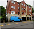
Anisa Mews, Talbot Lane, Newport
Flats near Charles Street and Newport city centre.
Image: © Jaggery
Taken: 29 Apr 2020
0.00 miles
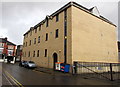
2

Ivor Street and Talbot Lane, Newport
A view from the top of Park Square Multi-Storey Car Park.
The grey roofed building in the foreground on the right belongs to the Salvation Army as does the small building with a red cross.
On the left is Mynydd Seion a Welsh Independent chapel.
The square tower in the centre in the distance belongs to St Mary's Roman Catholic Church in Stow Hill.
The tall office block is the Chartist Tower and is currently the tallest building in Newport at 173 feet.
Image: © Robin Drayton
Taken: 1 Jun 2009
0.01 miles
3
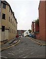
Talbot Lane, Newport city centre
From Charles Street along Talbot Lane towards Hill Street and Ivor Street.
Double yellow lines on both sides of Talbot Lane indicate no parking at any time.
Image: © Jaggery
Taken: 29 Apr 2020
0.01 miles
4
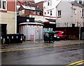
Wheelie bins and an electricity substation in Talbot Lane, Newport
The Western Power Distribution electricity substation is near the Charles Street junction.
Image: © Jaggery
Taken: 18 Dec 2014
0.01 miles
5
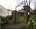
Eastern entrance to Chapel Park, Newport
This entrance is on a path ascending from the west side of Talbot Lane. Chapel Park is a small
city centre park on sloping ground between Talbot Lane to the east and Stow Hill to the west.
This entrance contrasts with the plain, unnamed western entrance. http://www.geograph.org.uk/photo/4319083
Image: © Jaggery
Taken: 22 Jan 2015
0.01 miles
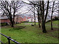
6
East side of Chapel Park, Newport
Chapel Park is a small city centre park on sloping ground between Stow Hill
to the west and Talbot Lane to the east (ahead). http://www.geograph.org.uk/photo/4319075
Image: © Jaggery
Taken: 22 Jan 2015
0.01 miles
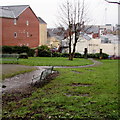
7
Down Chapel Park, Newport
Chapel Park is a small city centre park on sloping ground between Stow Hill on this side
and Talbot Lane, about 80 metres to the east, and at several metres lower elevation.
Image: © Jaggery
Taken: 22 Jan 2015
0.01 miles
8

Talbot Lane electricity substation, Newport
The large cabinet at the edge of Anisa Mews flats is a Western Power Distribution electricity substation.
Image: © Jaggery
Taken: 29 Apr 2020
0.02 miles
9
Talbot Lane side of Jobcentre Plus, Newport
The entrance is around the far corner, from Charles Street. http://www.geograph.org.uk/photo/2296530
Image: © Jaggery
Taken: 10 Jan 2015
0.02 miles
10
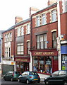
Carpet Gallery, Charles Street, Newport
Carpet and rug retailers.
Image: © Jaggery
Taken: 20 Dec 2009
0.02 miles