IMAGES TAKEN NEAR TO
High Street, NEWPORT, NP20 1FW
Introduction
This page details the photographs taken nearby to High Street, NP20 1FW by members of the Geograph project.
The Geograph project started in 2005 with the aim of publishing, organising and preserving representative images for every square kilometre of Great Britain, Ireland and the Isle of Man.

There are currently over 7.5m images from over14,400 individuals and you can help contribute to the project by visiting https://www.geograph.org.uk
Image Map
Images are licensed for reuse under creativecommons.org/licenses/by-sa/2.0
Notes
- Clicking on the map will re-center to the selected point.
- The higher the marker number, the further away the image location is from the centre of the postcode.
Image Listing (3192 Images Found)
Images are licensed for reuse under creativecommons.org/licenses/by-sa/2.0
Image
Details
Distance
1
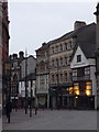
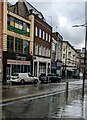
Newport: north end of High Street
High Street curves at its northern end to meet Upper Dock Street behind us. Among the buildings visible here is the Olde Murenger House, Newport's oldest pub - a Grade II listed building wporting its original 16th century beams.
Image: © Chris Downer
Taken: 20 Feb 2011
0.00 miles
2
Infusion, Newport
High Street bar and lounge. The subtext on the name board is "a cocktail of sport and music".
UPDATE May 2013. Premises now occupied by Cozy Joe's. http://www.geograph.org.uk/photo/3469370
Image: © Jaggery
Taken: 21 Oct 2012
0.00 miles
3
Cozy Joe's, Newport
The High Street bar opened in the spring of 2013 in premises previously occupied by Infusion. http://www.geograph.org.uk/photo/3190319
Image: © Jaggery
Taken: 21 May 2013
0.00 miles
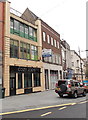
4
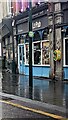
Parc Central, High Street, Newport
Parc Central is Parc Pantry's third premises in Newport. It opened here at 16 High Street in November 2016.
Parc Pantry also has premises in the Malpas area of Newport http://www.geograph.org.uk/photo/4145240 and in the city's Belle Vue Park.
Image: © Jaggery
Taken: 4 Mar 2017
0.00 miles
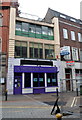
5
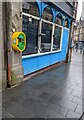
Rewind Retro Bar, 16 High Street, Newport
Viewed in February 2022. Falafilo Island https://www.geograph.org.uk/photo/5881190 was here in August 2018.
Image: © Jaggery
Taken: 22 Feb 2022
0.00 miles
6

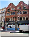
Former Page premises to let (or may sell), High Street, Newport
Viewed across High Street in mid November 2015.
See http://www.geograph.org.uk/photo/1720416 for an earlier view and some details of the building's earlier usage.
Image: © Jaggery
Taken: 15 Nov 2015
0.01 miles
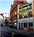
7
Le Pub, 14 High Street, Newport
Viewed in September 2017. Le Pub was previously in Caxton Place, Newport. http://www.geograph.org.uk/photo/5431203
Image: © Jaggery
Taken: 28 Sep 2017
0.01 miles
8
Yellow and green box on a High Street wall, Newport
The box holds a defibrillator for use in a potentially life-threatening emergency. The defibrillator applies a therapeutic electric current to the chest or heart to stop irregular contractions, or fibrillation, of the heart.
Image: © Jaggery
Taken: 22 Feb 2022
0.01 miles
9
Yellow and green box on a High Street wall, Newport
The box containing a defibrillator is on the wall of Le Pub at 14 High Street.
Image: © Jaggery
Taken: 2 Sep 2024
0.01 miles
10
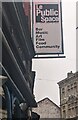
Le Public Space name sign, High Street, Newport
In September 2024 the sign located here https://www.geograph.org.uk/photo/7869415 shows
Bar
Music
Art
Film
Food
Community
Image: © Jaggery
Taken: 2 Sep 2024
0.01 miles