IMAGES TAKEN NEAR TO
Dumfries Place, NEWPORT, NP20 1EJ
Introduction
This page details the photographs taken nearby to Dumfries Place, NP20 1EJ by members of the Geograph project.
The Geograph project started in 2005 with the aim of publishing, organising and preserving representative images for every square kilometre of Great Britain, Ireland and the Isle of Man.

There are currently over 7.5m images from over14,400 individuals and you can help contribute to the project by visiting https://www.geograph.org.uk
Image Map
Images are licensed for reuse under creativecommons.org/licenses/by-sa/2.0
Notes
- Clicking on the map will re-center to the selected point.
- The higher the marker number, the further away the image location is from the centre of the postcode.
Image Listing (1341 Images Found)
Images are licensed for reuse under creativecommons.org/licenses/by-sa/2.0
Image
Details
Distance
1
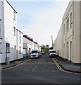
NE along Dumfries Place, Newport
Looking to the northeast along Dumfries Place from Lower Dock Street.
The sign on the left shows that Dumfries Place is not a through route for vehicles.
For walkers and cyclists, Dumfries Place leads to the A4042 Usk Way.
Image: © Jaggery
Taken: 7 May 2020
0.01 miles
2
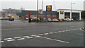
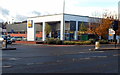
New Lidl store, Usk Way, Newport
Located on the corner of Granville Street and Usk Way. The store opened in September 2010.
Despite the sometimes gloomy prospects in other areas of the British economy, the food retail sector appears to be booming. This is now the third Lidl store in Newport. Nearby, a new Asda store http://www.geograph.org.uk/photo/1521195 opened in October 2009. A new Sainsbury's http://www.geograph.org.uk/photo/2059746 will open in Crindau, Newport on September 22 2010. In the east of the city, Tesco are planning to replace their store http://www.geograph.org.uk/photo/1580549 in Newport Retail Park, with one twice the size, in 2011. Morrisons intend to build a store as part of the Lysaghts Park development along Corporation Road.
Image: © Jaggery
Taken: 10 Sep 2010
0.02 miles
3
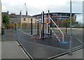
Children's play area, Dumfries Place, Newport
The play area is at the NE end of Dumfries Place. A Newport City Council sign on the railings advises parents or other adults accompanying children that only children between the ages of 4-12 should use this facility under their supervision.
Image: © Jaggery
Taken: 11 Apr 2012
0.02 miles
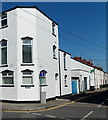
4
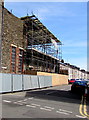
Caroline Street, Newport
Viewed across Lower Dock Street on June 24th 2018.
Scaffolding is on, and temporary fencing is alongside, Abundant Life Centre https://www.geograph.org.uk/photo/5831485
which was damaged by fire three months earlier.
Image: © Jaggery
Taken: 24 Jun 2018
0.02 miles
5
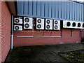
Extractor units on a wall of the Lidl Granville Street supermarket, Newport
Mitsubishi Heavy Industries Ltd Inverter units on the left, LU-VE Contardo (Italy) units on the right.
Image: © Jaggery
Taken: 9 Feb 2016
0.03 miles
6
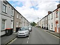
Newport, Caroline Street
Terraced houses.
Image: © Mike Faherty
Taken: 11 Jul 2016
0.03 miles
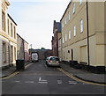
7
Dock Street name sign, Newport
Viewed across Lower Dock Street at the corner of Dumfries Place. The old-style name sign on the left
is a reminder that the street was formerly Dock Street, which was split into Lower Dock Street and Upper Dock Street when the Kingsway Centre was built, severing the street into two disconnected parts.
Image: © Jaggery
Taken: 21 Sep 2014
0.03 miles
8
Dead-end Powell's Place, Newport
Powell's Place extends for 50 metres from Lower Dock Street to a high stone wall.
Image: © Jaggery
Taken: 7 May 2020
0.03 miles
9
![History at your feet [2]](https://s1.geograph.org.uk/geophotos/01/61/43/1614309_898c4d23_120x120.jpg)
History at your feet [2]
The former use of some of the premises in Lower Dock Street http://www.geograph.org.uk/photo/1614301 is identified at pavement level.
Image: © Robin Drayton
Taken: 1 Oct 2008
0.03 miles
10
Lidl's Granville Street store, Newport
Viewed across Usk Way (the A4042). This Lidl's store opened in September 2010.
Image: © Jaggery
Taken: 3 Nov 2012
0.03 miles