IMAGES TAKEN NEAR TO
NP1 9NF
Introduction
This page details the photographs taken nearby to NP1 9NF by members of the Geograph project.
The Geograph project started in 2005 with the aim of publishing, organising and preserving representative images for every square kilometre of Great Britain, Ireland and the Isle of Man.

There are currently over 7.5m images from over14,400 individuals and you can help contribute to the project by visiting https://www.geograph.org.uk
Image Map
Images are licensed for reuse under creativecommons.org/licenses/by-sa/2.0
Notes
- Clicking on the map will re-center to the selected point.
- The higher the marker number, the further away the image location is from the centre of the postcode.
Image Listing (115 Images Found)
Images are licensed for reuse under creativecommons.org/licenses/by-sa/2.0
Image
Details
Distance
1
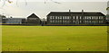
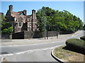
Bassaleg School
Viewed across playing fields from the fence at the eastern edge of the school.
The local pronunciation of Bassaleg is similar to "Baze-lig" (rhymes with Daze Gig) or Baze-uh-lig. (uh is the indistinct sound known as a schwa).
A visitor asking for directions to "bass-a-leg" is likely to encounter a blank stare, at least momentarily.
Image: © Jaggery
Taken: 19 Sep 2009
0.00 miles
2
Bassaleg Comprehensive School
Viewed from Pen Y Lan Road.
Image: © Robin Drayton
Taken: 26 Dec 2008
0.03 miles
3
Court Crescent, Bassaleg
Viewed from near the edge of the Forge Road roundabout.
Image: © Jaggery
Taken: 19 Sep 2009
0.09 miles
4
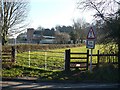
Glebe House, Forge Road, Newport
Located opposite Vicarage Close. A glebe house was one built on land attached to a parish church, in this case, St Basil's.http://www.geograph.org.uk/photo/1038070
Forge Road was formerly Forge Lane. I don't know exactly when it was renamed, but it was still Forge Lane in the 1960s. The name Forge Lane survives for the northern end of the old lane, about 100 metres in length, which is a few metres west of the course of Forge Road (A4072).
Image: © Jaggery
Taken: 19 Sep 2009
0.09 miles
5
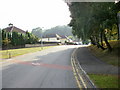
The A468 at Bassaleg
The A468 approaching a roundabout on a junction with the A467 at Bassaleg.
Image: © Philip Halling
Taken: 26 Jun 2010
0.12 miles
6
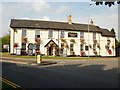
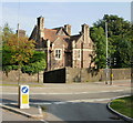
Tredegar Arms, Bassaleg
At 4 Caerphilly Road, Bassaleg, at the north end of Forge Road.
Not to be confused with the Tredegar Arms, Rogerstone http://www.geograph.org.uk/photo/1664734 little more than a mile away (less than 2 kilometres)
Image: © Jaggery
Taken: 19 Sep 2009
0.12 miles
7
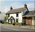
Bassaleg : Cottage Tea Rooms
Located at 6 Caerphilly Road.
Image: © Jaggery
Taken: 19 Sep 2009
0.12 miles
8
Birch Trees, Bassaleg
Birch Trees is a cul-de-sac on the south side of the A468 Caerphilly Road.
Image: © Jaggery
Taken: 19 Mar 2019
0.13 miles
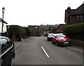
10
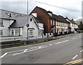
Houses on the south side of Caerphilly Road, Bassaleg
The house on the left is on the corner of Forge Road.
Image: © Jaggery
Taken: 19 Mar 2019
0.14 miles