IMAGES TAKEN NEAR TO
Malcolm Sargent Close, NEWPORT, NP19 9RH
Introduction
This page details the photographs taken nearby to Malcolm Sargent Close, NP19 9RH by members of the Geograph project.
The Geograph project started in 2005 with the aim of publishing, organising and preserving representative images for every square kilometre of Great Britain, Ireland and the Isle of Man.

There are currently over 7.5m images from over14,400 individuals and you can help contribute to the project by visiting https://www.geograph.org.uk
Image Map
Images are licensed for reuse under creativecommons.org/licenses/by-sa/2.0
Notes
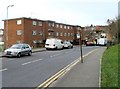
- Clicking on the map will re-center to the selected point.
- The higher the marker number, the further away the image location is from the centre of the postcode.
Image Listing (159 Images Found)
Images are licensed for reuse under creativecommons.org/licenses/by-sa/2.0
Image
Details
Distance
1
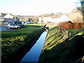
Drainage channel alongside A48, Ringland, Newport
Viewed from a wooden fence on the western side of the A48 (Ringland Way). A small stream from higher ground in Ringland is now a drainage channel, here near the edge of Sullivan Circle and Malcolm Sargent Close. A short distance behind the camera, it is named Liswerry Pill Reen.
Image: © Jaggery
Taken: 5 Dec 2010
0.05 miles
2
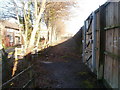
Wooden fence alongside Ringland Way, Newport
A wooden fence extends for hundreds of metres along the northern side of the A48 (Ringland Way) to shield houses from the noise of the busy A road. There are a few gaps in the fence to give pedestrians access to the pavement alongside the A48.
Image: © Jaggery
Taken: 5 Dec 2010
0.05 miles
3
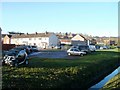
Sullivan Circle, Newport
Houses along a bend in Sullivan Circle, viewed from a fence http://www.geograph.org.uk/photo/2189199 on the north side of Ringland Way (A48). A drainage channel http://www.geograph.org.uk/photo/2189191 is in the lower right corner.
Image: © Jaggery
Taken: 5 Dec 2010
0.05 miles
4
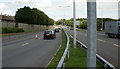
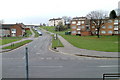
Ringland Way, Newport
Ringland Way heads away from the Spytty Lane roundabout.
Image: © Jaggery
Taken: 20 Aug 2009
0.05 miles
5
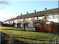
Malcolm Sargent Close, Newport
Houses on the south side of the close, viewed from a fence http://www.geograph.org.uk/photo/2189199 on the north side of Ringland Way (A48).
Image: © Jaggery
Taken: 5 Dec 2010
0.05 miles
6
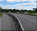
A48 towards M4 motorway junction 24, Newport
Viewed from the corner of Balfe Road. The sign on the right points along the A48 towards the M4 motorway.
M4 Junction 24 at the Coldra is nearly 3km ahead.
Image: © Jaggery
Taken: 5 Jul 2016
0.07 miles
7
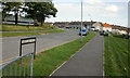
Aberthaw Road, Alway, Newport
Aberthaw Road heads away from Alway Community Centre http://www.geograph.org.uk/photo/1581424 towards Ringland Circle.
Image: © Jaggery
Taken: 20 Aug 2009
0.08 miles
8
Aberthaw Road, Newport
Viewed across Ringland Circle, Aberthaw Road heads towards Alway.
Image: © Jaggery
Taken: 26 Nov 2010
0.08 miles
9
Ringland Circle flats, Newport
A building containing 12 flats, located on the west side of Ringland Circle, near the turning for Aberthaw Road. http://www.geograph.org.uk/photo/2175759
Image: © Jaggery
Taken: 26 Nov 2010
0.09 miles
10
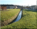
Small stream, Ringland, Newport
This small, unnamed stream drains much of Ringland. Viewed here from the corner of Aberthaw Road and Ringland Circle, looking along the east side of Sullivan Circle.
The stream empties into Liswerry Pill Reen (drainage channel), about a kilometre away.
Image: © Jaggery
Taken: 5 Dec 2010
0.09 miles