IMAGES TAKEN NEAR TO
Sullivan Circle, NEWPORT, NP19 9RF
Introduction
This page details the photographs taken nearby to Sullivan Circle, NP19 9RF by members of the Geograph project.
The Geograph project started in 2005 with the aim of publishing, organising and preserving representative images for every square kilometre of Great Britain, Ireland and the Isle of Man.

There are currently over 7.5m images from over14,400 individuals and you can help contribute to the project by visiting https://www.geograph.org.uk
Image Map
Images are licensed for reuse under creativecommons.org/licenses/by-sa/2.0
Notes
- Clicking on the map will re-center to the selected point.
- The higher the marker number, the further away the image location is from the centre of the postcode.
Image Listing (164 Images Found)
Images are licensed for reuse under creativecommons.org/licenses/by-sa/2.0
Image
Details
Distance
1
Aberthaw Road, Alway, Newport
Aberthaw Road heads away from Alway Community Centre http://www.geograph.org.uk/photo/1581424 towards Ringland Circle.
Image: © Jaggery
Taken: 20 Aug 2009
0.05 miles
2
Aberthaw Road, Newport
Viewed across Ringland Circle, Aberthaw Road heads towards Alway.
Image: © Jaggery
Taken: 26 Nov 2010
0.05 miles
3
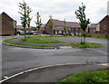
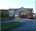
Recently-built houses, Alway, Newport
On the SE side of Alway Parade shops, viewed in July 2016.
None of these houses appear in a Google Earth Street View taken in August 2012.
Image: © Jaggery
Taken: 2 Jul 2016
0.05 miles
4
Corner of Penkin Hill and John Ireland Close, Alway, Newport
Viewed across Penkin Hill.
Before I researched this photo, the only John Ireland I knew was a Canadian-born actor and film director. However, this street was named to commemorate John Nicholson Ireland (1879–1962), an English composer. Several nearby streets are named after composers.
Image: © Jaggery
Taken: 5 Dec 2010
0.07 miles
5
Kingdom Hall, Alway, Newport
A Kingdom Hall is a place of worship used by Jehovah's Witnesses. They use the term rather than 'church' because the biblical use of 'church' usually refers to the congregation of people rather than a structure.
This Kingdom Hall is on the south side of Penkin Hill, opposite John Ireland Close. http://www.geograph.org.uk/photo/2188166
Image: © Jaggery
Taken: 5 Dec 2010
0.07 miles
6
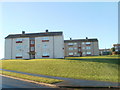
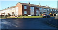
Penkin Hill flats, Newport
Two buildings, each containing six flats, located on the SE side of Penkin Hill, viewed across Aberthaw Road.
Image: © Jaggery
Taken: 5 Dec 2010
0.07 miles
7
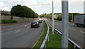
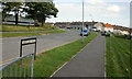
Ringland Way, Newport
Ringland Way heads away from the Spytty Lane roundabout.
Image: © Jaggery
Taken: 20 Aug 2009
0.07 miles
8
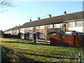
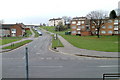
Malcolm Sargent Close, Newport
Houses on the south side of the close, viewed from a fence http://www.geograph.org.uk/photo/2189199 on the north side of Ringland Way (A48).
Image: © Jaggery
Taken: 5 Dec 2010
0.07 miles
9
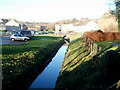
Drainage channel alongside A48, Ringland, Newport
Viewed from a wooden fence on the western side of the A48 (Ringland Way). A small stream from higher ground in Ringland is now a drainage channel, here near the edge of Sullivan Circle and Malcolm Sargent Close. A short distance behind the camera, it is named Liswerry Pill Reen.
Image: © Jaggery
Taken: 5 Dec 2010
0.08 miles
10
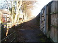
Wooden fence alongside Ringland Way, Newport
A wooden fence extends for hundreds of metres along the northern side of the A48 (Ringland Way) to shield houses from the noise of the busy A road. There are a few gaps in the fence to give pedestrians access to the pavement alongside the A48.
Image: © Jaggery
Taken: 5 Dec 2010
0.08 miles