IMAGES TAKEN NEAR TO
John Ireland Close, NEWPORT, NP19 9NY
Introduction
This page details the photographs taken nearby to John Ireland Close, NP19 9NY by members of the Geograph project.
The Geograph project started in 2005 with the aim of publishing, organising and preserving representative images for every square kilometre of Great Britain, Ireland and the Isle of Man.

There are currently over 7.5m images from over14,400 individuals and you can help contribute to the project by visiting https://www.geograph.org.uk
Image Map
Images are licensed for reuse under creativecommons.org/licenses/by-sa/2.0
Notes
- Clicking on the map will re-center to the selected point.
- The higher the marker number, the further away the image location is from the centre of the postcode.
Image Listing (125 Images Found)
Images are licensed for reuse under creativecommons.org/licenses/by-sa/2.0
Image
Details
Distance
1
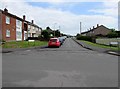
John Ireland Close, Alway, Newport
Cul-de-sac extending for 150 metres from Penkin Hill.
John Nicholson Ireland (1879-1962) was an English composer.
Several nearby streets are named after composers.
Image: © Jaggery
Taken: 2 Jul 2016
0.01 miles
2
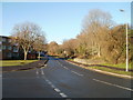
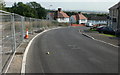
Newport : Ringland Circle viewed from the corner of Aberthaw Road
Ringland Circle passes the edge of Ringland Wood, on the right.
Image: © Jaggery
Taken: 5 Dec 2010
0.03 miles
3
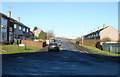
John Ireland Close, Alway, Newport
Viewed from Penkin Hill. John Nicholson Ireland (1879-1962) was an English composer. Several nearby streets are named after composers.
Image: © Jaggery
Taken: 5 Dec 2010
0.06 miles
4
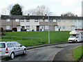
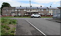
Stanford Road, Newport
Housing on the east side of the Aberthaw Road end of Stanford Road. Located at the edge of Alway/Bishpool, built in the 1950s.
Image: © Jaggery
Taken: 16 Nov 2009
0.06 miles
5
Rooftop solar panels, Penkin Hill, Alway, Newport
Penkin Hill houses viewed from Penkin Close.
Image: © Jaggery
Taken: 2 Jul 2016
0.07 miles
6
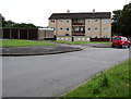
Penkin Hill flats and lockup garages, Alway, Newport
On the north side of Penkin Hill, between John Ireland Close and Aberthaw Road.
Image: © Jaggery
Taken: 2 Jul 2016
0.08 miles
7
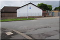
Kingdom Hall, Alway, Newport
Located on the south side of Penkin Hill, opposite John Ireland Close, http://www.geograph.org.uk/photo/5017289, the Kingdom Hall is a place of worship used by Jehovah's Witnesses, who use the term rather than church because the biblical use of church usually refers to the congregation of people rather than a structure. The blue plaque on the white wall shows JW.ORG, the website of Jehovah’s Witnesses.
Image: © Jaggery
Taken: 2 Jul 2016
0.08 miles
8
Elgar Circle, Alway
The view midway down Elgar Circle. Behind the fence on the left are house foundations.
Image: © Jaggery
Taken: 10 Sep 2009
0.08 miles
9
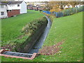
Stream, Ringland Circle, Newport
A stream, running off Dents Hill, flows into a culvert under Ringland Circle.
The stream empties into Liswerry Pill Reen.
Image: © Jaggery
Taken: 16 Nov 2009
0.08 miles
10
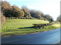
Edge of Ringland Wood, Newport
Viewed across Ringland Circle. The open space at the edge of the wood is immediately south of Bishpool Methodist Church. http://www.geograph.org.uk/photo/1592806
Image: © Jaggery
Taken: 5 Dec 2010
0.08 miles