IMAGES TAKEN NEAR TO
Morley Close, NEWPORT, NP19 9LS
Introduction
This page details the photographs taken nearby to Morley Close, NP19 9LS by members of the Geograph project.
The Geograph project started in 2005 with the aim of publishing, organising and preserving representative images for every square kilometre of Great Britain, Ireland and the Isle of Man.

There are currently over 7.5m images from over14,400 individuals and you can help contribute to the project by visiting https://www.geograph.org.uk
Image Map
Images are licensed for reuse under creativecommons.org/licenses/by-sa/2.0
Notes
- Clicking on the map will re-center to the selected point.
- The higher the marker number, the further away the image location is from the centre of the postcode.
Image Listing (75 Images Found)
Images are licensed for reuse under creativecommons.org/licenses/by-sa/2.0
Image
Details
Distance
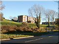
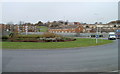
1
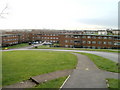
Morley Close flats, Newport
Viewed from Dunstable Road. Morley Close contains 36 flats, 12 in each of 3 buildings, built in the 1960s.
Image: © Jaggery
Taken: 26 Nov 2010
0.02 miles
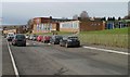
2
Open space, Dunstable Road, Newport
The view north along Dunstable Road from opposite Morley Close. http://www.geograph.org.uk/photo/2175714
Image: © Jaggery
Taken: 26 Nov 2010
0.04 miles
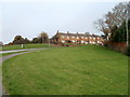
3
Row of 5 houses, Dunstable Road, Newport
Looking along Dunstable Road towards the junction with Dowland Close. http://www.geograph.org.uk/photo/2175654
The reddish building in the background is part of Ringland Primary School. http://www.geograph.org.uk/photo/2175591
Image: © Jaggery
Taken: 26 Nov 2010
0.04 miles
4
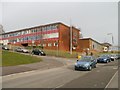
Newport : Ringland Primary School viewed from the west
Looking towards the corner of Dunstable Road and Dowland Close. http://www.geograph.org.uk/photo/2175654
http://www.geograph.org.uk/photo/2175582 to the view from the east.
The school has about 250 pupils (age range 4 to 11).
Image: © Jaggery
Taken: 26 Nov 2010
0.04 miles
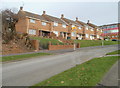
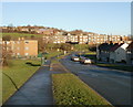
5
Morley Close flats, Newport
The view from Ringland Circle towards flats on higher ground. The building in the centre is one of three blocks of 12 flats on Morley Close. The other two blocks are on the right.
Image: © Jaggery
Taken: 5 Dec 2010
0.06 miles
6
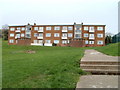
Newport : Morley Close flats viewed from Ringland Circle
Morley Close contains 3 buildings, each with 12 flats. This is one of the buildings, viewed from the Ringland Circle side.
Image: © Jaggery
Taken: 26 Nov 2010
0.06 miles
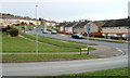
7
Looking down Aberthaw Road, Newport
The view from near the corner of Penkin Hill, looking along Aberthaw Road towards the junction with Ringland Circle. The long row of buildings in the middle distance are flats on Morley Close.
Image: © Jaggery
Taken: 5 Dec 2010
0.06 miles
8
Hendre Farm Drive, Newport
Looking east along Hendre Farm Drive from the southern end of Dunstable Road.
Image: © Jaggery
Taken: 26 Nov 2010
0.08 miles
9
Ringland Way roundabout, Newport
Looking towards Ringland Circle and Hendre Farm Drive from the southern side of the Ringland Way roundabout.
Image: © Jaggery
Taken: 26 Nov 2010
0.08 miles
10
Newport : Ringland Primary School viewed from the east
The view along Dunstable Road. The school has about 250 pupils (age range 4 to 11). http://www.geograph.org.uk/photo/2175591 to the view from the west.
Image: © Jaggery
Taken: 26 Nov 2010
0.08 miles