IMAGES TAKEN NEAR TO
Mountbatten Close, NEWPORT, NP19 9GT
Introduction
This page details the photographs taken nearby to Mountbatten Close, NP19 9GT by members of the Geograph project.
The Geograph project started in 2005 with the aim of publishing, organising and preserving representative images for every square kilometre of Great Britain, Ireland and the Isle of Man.

There are currently over 7.5m images from over14,400 individuals and you can help contribute to the project by visiting https://www.geograph.org.uk
Image Map
Images are licensed for reuse under creativecommons.org/licenses/by-sa/2.0
Notes
- Clicking on the map will re-center to the selected point.
- The higher the marker number, the further away the image location is from the centre of the postcode.
Image Listing (52 Images Found)
Images are licensed for reuse under creativecommons.org/licenses/by-sa/2.0
Image
Details
Distance
1
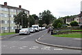
Mountbatten Close, Ringland, Newport
Cul-de-sac on the south side of Beatty Road.
Four-storey block of flats http://www.geograph.org.uk/photo/5004908 on the east side, two-storey houses on the west side.
Image: © Jaggery
Taken: 22 Jun 2016
0.02 miles
2
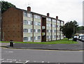
Four-storey block of flats, Ringland, Newport
On the east side of Mountbatten Close, viewed across Beatty Road.
Image: © Jaggery
Taken: 22 Jun 2016
0.03 miles
3
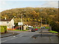
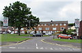
Junction of Beatty Road and Ringland Way, Newport
Looking down Beatty Road across the Ringland Way roundabout towards Scotch Wood. On the left is the Howe Circle http://www.geograph.org.uk/photo/1592293 junction, with Mountbatten Close on the right.
Image: © Jaggery
Taken: 15 Nov 2009
0.05 miles
4
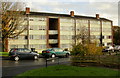
Mountbatten Close flats, Ringland, Newport
Housing on the east side of Mountbatten Close.
Image: © Jaggery
Taken: 15 Nov 2009
0.05 miles
5
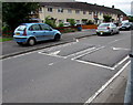
Speed bumps, Beatty Road, Ringland, Newport
In a 20mph maximum speed zone on the approach to a school.
Image: © Jaggery
Taken: 22 Jun 2016
0.06 miles
6
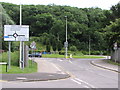
Directions sign for vehicles leaving Ringland, Newport
Facing Beatty Road on the corner of Howe Circle. At the A48 roundabout ahead, turn left for the M4 motorway (junction 24) or right for the city centre. A factory access road is on the far side of the roundabout.
Image: © Jaggery
Taken: 22 Jun 2016
0.06 miles
7
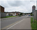
Start of the 20 zone at the NE edge of Ringland, Newport
The 50mph speed limit on the A48 behind the camera drops to 20mph along Beatty Road.
The Mountbatten Close (left) and Howe Circle (right) junctions are ahead.
Image: © Jaggery
Taken: 22 Jun 2016
0.07 miles
8
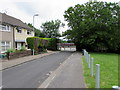
Jellicoe Close school entrance gates, Ringland, Newport
A side entrance from Jellicoe Close to Milton Junior School and
Milton Infant School. The main entrance is from Hendre Farm Drive.
Image: © Jaggery
Taken: 22 Jun 2016
0.08 miles
9

Row of houses on the south side of Beatty Road, Ringland, Newport
One of several rows of houses joined at right angles. Another row of houses is behind the house on the right.
Image: © Jaggery
Taken: 22 Jun 2016
0.08 miles
10
End of the 20 zone, Hood Road, Ringland, Newport
The 20mph speed limit on Beatty Road increases to 30mph along Hood Road.
Image: © Jaggery
Taken: 22 Jun 2016
0.08 miles