IMAGES TAKEN NEAR TO
Eisteddfod Walk, NEWPORT, NP19 9EU
Introduction
This page details the photographs taken nearby to Eisteddfod Walk, NP19 9EU by members of the Geograph project.
The Geograph project started in 2005 with the aim of publishing, organising and preserving representative images for every square kilometre of Great Britain, Ireland and the Isle of Man.

There are currently over 7.5m images from over14,400 individuals and you can help contribute to the project by visiting https://www.geograph.org.uk
Image Map
Images are licensed for reuse under creativecommons.org/licenses/by-sa/2.0
Notes
- Clicking on the map will re-center to the selected point.
- The higher the marker number, the further away the image location is from the centre of the postcode.
Image Listing (93 Images Found)
Images are licensed for reuse under creativecommons.org/licenses/by-sa/2.0
Image
Details
Distance
1
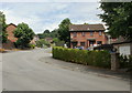
William Morris Drive, Newport
William Morris Drive heads north away from Chepstow Road. The street contains a mixture of flats and semi-detached houses.
William Morris (1834-1896) was an English textile designer, artist, writer and socialist.
Image: © Jaggery
Taken: 1 Jul 2010
0.03 miles
2
William Morris Drive, lower left arm, Newport
William Morris Drive, on the north side of Chepstow Road, two left 'arms' or branches, and one right 'arm' branching to the west and east of the central route.
This is the left arm nearer to Chepstow Road.
William Morris (1834-1896) was an English textile designer, artist, writer and socialist.
Image: © Jaggery
Taken: 1 Jul 2010
0.03 miles
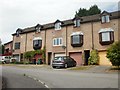
3
Kier Hardie Drive, Newport
Houses on Kier Hardie Drive, adjacent to the turning for Clement Atlee Drive.
Embarrassingly for the local council, the street name signs (and subsequently maps based on them) are both wrongly spelt - Kier instead of Keir and Atlee for Attlee.
Keir Hardie (1856–1915) was the first Independent Labour Member of Parliament. He is regarded as one of the primary founders of the Independent Labour Party as well as the Labour Party of which it was later a part.
Clement Attlee (1883–1967) was leader of the Labour Party from 1935 to 1955 and Prime Minister of the UK from 1945 to 1951.
Image: © Jaggery
Taken: 1 Jul 2010
0.03 miles
4
Old Boundary Marker by the B4237, Chepstow Road
Parish Boundary Marker by the B4237 (was A48), in Ringland community (Newport District), Chepstow Road, at junction with Eisteddfod Walk, on verge. MON_NPT01pb is diagonally opposite on the corner of Bishpool Lane: Image
Inscription reads:-
: NEWPORT / BOROUGH : : 1889 : : CHRISTCHURCH / HIGHWAY / DISTRICT :
Surveyed
Milestone Society National ID: MON_NPT02pb
Image: © M Faherty
Taken: Unknown
0.05 miles
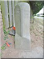
5
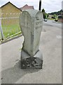
Old Boundary Marker by the B4237, Chepstow Road
Parish Boundary Marker by the B4237 (was A48), in Ringland community (Newport District), Chepstow Road, at junction with Bishpool Lane, on pavement. MON_NPT01pb is diagonally opposite on the corner of Eisteddfod Walk: Image
Inscription reads:-
: COUNTY / MONMOUTH : : 1889 : : NEWPORT / BOROUGH :
Surveyed
Milestone Society National ID: MON_NPT01pb
Image: © M Faherty
Taken: 10 Jul 2016
0.07 miles
6
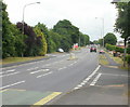
Tree-lined section of Chepstow Road, Newport
Viewed from the northwest edge of the Treberth estate.
Image: © Jaggery
Taken: 24 Jun 2010
0.07 miles
7

Esso Treberth Service Station, Newport
Located on the north side of Chepstow Road, across the road from the Treberth housing estate.
Image: © Jaggery
Taken: 18 Oct 2009
0.07 miles
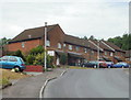
8
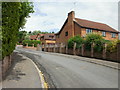
Eisteddfod Walk, Newport
A cul-de-sac of 8 houses connecting with the north side of Chepstow Road. The houses were built in 1988, one of three years that the National Eisteddfod of Wales has been held in Newport.
Image: © Jaggery
Taken: 1 Jul 2010
0.07 miles
9
Will Paynter Walk, Newport
Will Paynter Walk extends from the northeast side of William Morris Drive to the edge of George Lansbury Drive. This view is of the William Morris Drive end.
Cardiff-born Will Paynter (1903-1984) was a Welsh miners' leader involved in the hunger marches of the 1930s.
Image: © Jaggery
Taken: 1 Jul 2010
0.07 miles
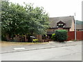
10
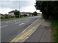
Chepstow Road bus stop, Royal Oak, Newport
This side of the road for buses from the city centre towards Ringland and Chepstow.
Image: © Jaggery
Taken: 22 Jun 2016
0.08 miles