IMAGES TAKEN NEAR TO
Chepstow Road, NEWPORT, NP19 9BL
Introduction
This page details the photographs taken nearby to Chepstow Road, NP19 9BL by members of the Geograph project.
The Geograph project started in 2005 with the aim of publishing, organising and preserving representative images for every square kilometre of Great Britain, Ireland and the Isle of Man.

There are currently over 7.5m images from over14,400 individuals and you can help contribute to the project by visiting https://www.geograph.org.uk
Image Map
Images are licensed for reuse under creativecommons.org/licenses/by-sa/2.0
Notes
- Clicking on the map will re-center to the selected point.
- The higher the marker number, the further away the image location is from the centre of the postcode.
Image Listing (95 Images Found)
Images are licensed for reuse under creativecommons.org/licenses/by-sa/2.0
Image
Details
Distance
1
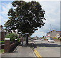
Bus stop and shelter near a tree, Chepstow Road, Newport
This stop is for buses to the city centre via Beechwood and Maindee.
Image: © Jaggery
Taken: 21 Jun 2019
0.02 miles
2
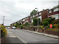
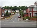
Western arm of Farmwood Close, Newport
At the top of a short climb http://www.geograph.org.uk/photo/1930881 from Chepstow Road, Farmwood Close branches to right (SW) and left (NE).
This is the SW view, looking towards Lawrence Hill Avenue.
Image: © Jaggery
Taken: 24 Jun 2010
0.03 miles
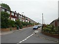
3
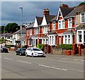
Row of brick houses, Chepstow Road, Newport
On the north side of the B4237 Chepstow Road.
Image: © Jaggery
Taken: 21 Jun 2019
0.03 miles
4
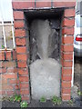
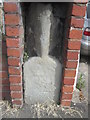
Old Milestone by the B4237 in Newport
This old weathered milestone has been built into the gate pillar for #555 Chepstow Road, on the north side of the road.
Inscription once read:- : (Newport 2 / Chepstow 14) :
Carved bench mark on lower face.
Milestone Society National ID: MON_CWNP14
Image: © Kirstie Hackett
Taken: 8 Mar 2015
0.04 miles
5
Milestone - Newport 2
There is an OS cut mark on the base of this milestone. It marks a point 26.359m above mean sea level.
Image: © Adrian Dust
Taken: 25 May 2015
0.04 miles
6
Farmwood Close, Newport
Viewed from Chepstow Road. Farmwood Close forms a T shape. This view is of the tail of the T ; the two arms at the top of this view are to the SW http://www.geograph.org.uk/photo/1930891 and NE. http://www.geograph.org.uk/photo/1930899
Image: © Jaggery
Taken: 24 Jun 2010
0.04 miles
7
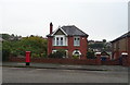
House on Chepstow Road, Newport
Showing position of Postbox No. NP19 44.
See Image] for postbox.
Image: © JThomas
Taken: 15 Oct 2019
0.05 miles
8
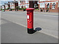
King George VI pillarbox, Chepstow Road, Newport
The pillarbox near Farmwood Close dates from the reign of King George VI (December 11th 1936 to February 6th 1952).
Image: © Jaggery
Taken: 21 Jun 2019
0.06 miles
9
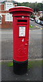
George VI postbox on Chepstow Road, Newport
Postbox No. NP19 44.
See Image] for context..
Image: © JThomas
Taken: 15 Oct 2019
0.06 miles
10
Eastern arm of Farmwood Close, Newport
At the top of a short climb http://www.geograph.org.uk/photo/1930881 from Chepstow Road, Farmwood Close branches to right (SW) and left (NE). This is the NE view.
Image: © Jaggery
Taken: 24 Jun 2010
0.06 miles