IMAGES TAKEN NEAR TO
Palm Square, NEWPORT, NP19 9AE
Introduction
This page details the photographs taken nearby to Palm Square, NP19 9AE by members of the Geograph project.
The Geograph project started in 2005 with the aim of publishing, organising and preserving representative images for every square kilometre of Great Britain, Ireland and the Isle of Man.

There are currently over 7.5m images from over14,400 individuals and you can help contribute to the project by visiting https://www.geograph.org.uk
Image Map
Images are licensed for reuse under creativecommons.org/licenses/by-sa/2.0
Notes
- Clicking on the map will re-center to the selected point.
- The higher the marker number, the further away the image location is from the centre of the postcode.
Image Listing (261 Images Found)
Images are licensed for reuse under creativecommons.org/licenses/by-sa/2.0
Image
Details
Distance
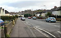
1

Sky van in Sycamore Avenue, Newport
Parked near the corner of Palm Square.
Text on the back of the van shows Believe in better and Sky Sports - 6 channels in HD (High Definition).
Image: © Jaggery
Taken: 16 Feb 2016
0.02 miles
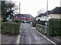
2
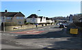
Sycamore Avenue, Newport
Viewed from near the junction with Somerton Road.
Image: © Jaggery
Taken: 24 Jan 2010
0.03 miles
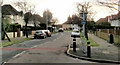
3
Palm Square, Newport
Viewed from Sycamore Avenue.
Image: © Jaggery
Taken: 24 Jan 2010
0.03 miles
4
Looking south along Hawthorn Avenue, Newport
The view from the corner of Sycamore Avenue, looking in the direction of the Libeneth Road roundabout.
Image: © Jaggery
Taken: 24 Jan 2010
0.03 miles
5
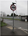
Vehicle weight limit sign, Somerton Road, Newport
On the corner of Sycamore Avenue at the start of the ascent https://www.geograph.org.uk/photo/6405325
to Somerton Road railway bridge which has a 7.5 tonnes vehicle weight limit.
The Cabin Salon https://www.geograph.org.uk/photo/6405323 is on the right.
Image: © Jaggery
Taken: 5 Mar 2020
0.03 miles
6
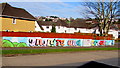
Inspire and Create in Somerton, Newport
The colourful mural on a Hawthorn Avenue wall is opposite this Welcome to Somerton. http://www.geograph.org.uk/photo/5270670
Image: © Jaggery
Taken: 16 Feb 2016
0.03 miles
7
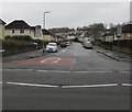
Junction of Somerton Road and Sycamore Avenue, Somerton, Newport
The 30mph speed limit on Somerton Road drops to 20mph along Sycamore Avenue.
Image: © Jaggery
Taken: 5 Mar 2020
0.04 miles
8
Western end of Sycamore Avenue, Newport
Looking east along Sycamore Avenue from Somerton Road on February 16th 2016.
A temporary yellow sign on the right tells pedestrians unable to use the nearby stepped temporary footbridge over the railway to wait here for a low floor bus, scheduled to arrive every 10 minutes. The bus will follow the road diversion (caused by the closure of the Somerton Road railway bridge). The journey will take about 20 minutes.
Image: © Jaggery
Taken: 16 Feb 2016
0.04 miles
9
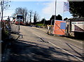
Closure of Somerton Road, Newport
Viewed from the corner of Sycamore Avenue in mid February 2016. The road ahead is closed during work to replace the railway bridge across the South Wales main line. Erected in 1850, the bridge was unsuitable to accommodate the overhead lines which will power electric trains on the South Wales main line. This project is one of many infrastructure changes needed for the electrification of the route.
Image: © Jaggery
Taken: 16 Feb 2016
0.04 miles
10
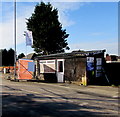
Somerton Road shack, Newport
Alongside Somerton Road near the Sycamore Avenue junction, viewed in mid February 2016 when the road ahead is closed. http://www.geograph.org.uk/photo/5270655
Image: © Jaggery
Taken: 16 Feb 2016
0.04 miles