IMAGES TAKEN NEAR TO
Chepstow Road, NEWPORT, NP19 8EN
Introduction
This page details the photographs taken nearby to Chepstow Road, NP19 8EN by members of the Geograph project.
The Geograph project started in 2005 with the aim of publishing, organising and preserving representative images for every square kilometre of Great Britain, Ireland and the Isle of Man.

There are currently over 7.5m images from over14,400 individuals and you can help contribute to the project by visiting https://www.geograph.org.uk
Image Map
Images are licensed for reuse under creativecommons.org/licenses/by-sa/2.0
Notes
- Clicking on the map will re-center to the selected point.
- The higher the marker number, the further away the image location is from the centre of the postcode.
Image Listing (323 Images Found)
Images are licensed for reuse under creativecommons.org/licenses/by-sa/2.0
Image
Details
Distance
1
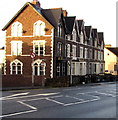
Row of three-storey houses, Eveswell, Newport
Extending for 35 metres on the south side of Chepstow Road,
between Tweedy Lane on the left and Eveswell Street on the right.
Image: © Jaggery
Taken: 23 Dec 2015
0.01 miles
2
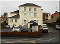
Kensington Court Clinic, Newport
197 Chepstow Road. Occupiers of the premises are Kensington Court Dental Care and the Complementary Medicine Centre.
Image: © Jaggery
Taken: 12 Nov 2009
0.03 miles
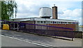
3
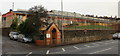
Eveswell Primary School, Newport
Located on the north side of Chepstow Road, between Kensington Grove and Batchelor Road.
The buildings shown here replaced old Victorian buildings in 1989.
The Nursery unit is housed in a separate building on the same campus. About 485 pupils (including the children in the nursery) attend the school.
Origin of the name Eveswell.
According to the school's website,
"Local history tells of a well that existed in the vicinity of the school and about a girl called Eve who supposedly fell into the well. This is where the area and the school got its name".
Image: © Jaggery
Taken: 12 Nov 2009
0.03 miles
4
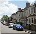
West end of St John's Road, Newport
Houses near the corner of Kensington Place, opposite St John the Evangelist church. http://www.geograph.org.uk/photo/1880568
Image: © Jaggery
Taken: 27 May 2010
0.03 miles
5
Ysgol Maes Ebbw Bach, St John's Road, Newport
Located in a former children's centre, Ysgol Maes Ebbw Bach is a satellite of the main school, Maes Ebbw http://www.geograph.org.uk/photo/2533870 located in Maesglas. Conversion work on the building was ongoing at the June 2012 date of this view. Completion is planned for September 2012.
Image: © Jaggery
Taken: 9 Jun 2012
0.03 miles
6
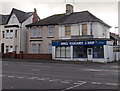
Former House Clearance & Shop, Maindee, Newport
At the October 2013 date of this view,there is a For Sale/To Let board in the window of the shop on the corner of Chepstow Road and Oxford Street.
An earlier occupier of the shop was Wales Poker League. http://www.geograph.org.uk/photo/1579627
Image: © Jaggery
Taken: 17 Oct 2013
0.04 miles
7
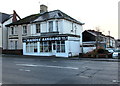
Maindee Bargains, Newport
Shop at 210 Chepstow Road on the corner of Oxford Street.
Image: © Jaggery
Taken: 23 Dec 2015
0.04 miles
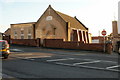
8
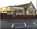
Seventh-day Adventist Church, Newport
On the south side of Chepstow Road, between Rosslyn Road and Tweedy Lane, opposite Eveswell Primary School.
Image: © Jaggery
Taken: 23 Dec 2015
0.04 miles
9
Seventh-Day Adventist Church, Newport
Located on Chepstow Road, between Rosslyn Road and Tweedy Lane.
Visible in the right background is Maindee Fire Station training tower. http://www.geograph.org.uk/photo/1561664
Image: © Jaggery
Taken: 24 Jan 2010
0.04 miles
10
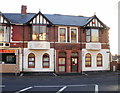
Eveswell Surgery, Newport
A three-doctor practice located at 254 Chepstow Road, on the corner of Rosslyn Road.
Image: © Jaggery
Taken: 24 Jan 2010
0.04 miles