IMAGES TAKEN NEAR TO
Tweedy Lane, NEWPORT, NP19 8DZ
Introduction
This page details the photographs taken nearby to Tweedy Lane, NP19 8DZ by members of the Geograph project.
The Geograph project started in 2005 with the aim of publishing, organising and preserving representative images for every square kilometre of Great Britain, Ireland and the Isle of Man.

There are currently over 7.5m images from over14,400 individuals and you can help contribute to the project by visiting https://www.geograph.org.uk
Image Map
Images are licensed for reuse under creativecommons.org/licenses/by-sa/2.0
Notes
- Clicking on the map will re-center to the selected point.
- The higher the marker number, the further away the image location is from the centre of the postcode.
Image Listing (267 Images Found)
Images are licensed for reuse under creativecommons.org/licenses/by-sa/2.0
Image
Details
Distance
1
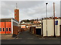
Tweedy Lane, Maindee, Newport
Viewed from Archibald Street looking past Maindee Fire Station http://www.geograph.org.uk/photo/3283303 towards Chepstow Road.
Image: © Jaggery
Taken: 5 Jan 2013
0.01 miles
2
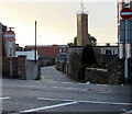
Tweedy Lane, Newport
Extending for 150 metres from Chepstow Road on this side to Conway Road and Archibald Street ahead.
Maindee Fire Station's tower http://www.geograph.org.uk/photo/1561664 is in the distance.
Image: © Jaggery
Taken: 23 Dec 2015
0.01 miles
3
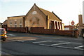
Seventh-Day Adventist Church, Newport
Located on Chepstow Road, between Rosslyn Road and Tweedy Lane.
Visible in the right background is Maindee Fire Station training tower. http://www.geograph.org.uk/photo/1561664
Image: © Jaggery
Taken: 24 Jan 2010
0.02 miles
4
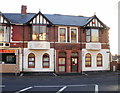
Eveswell Surgery, Newport
A three-doctor practice located at 254 Chepstow Road, on the corner of Rosslyn Road.
Image: © Jaggery
Taken: 24 Jan 2010
0.02 miles
5
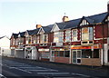
Chepstow Road shops between Rochester Road and Rosslyn Road
From east to west (left to right)
Rapier Employment Ltd, recruitment agency, 266 Chepstow Road, on the corner of Rochester Road.
Scissorhands, hairdresser.
Co-operative pharamcy.
Hancock Life & Pensions.
New Canton Chinese takeaway.
Standard Balti Indian takeaway, 256 Chepstow Road.
To the right of Standard Balti, out of shot, is Eveswell Surgery. http://www.geograph.org.uk/photo/1694285
Image: © Jaggery
Taken: 24 Jan 2010
0.02 miles
6
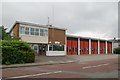
Maindee Fire Station
Maindee Fire Station, Archibald Street, Newport
Image: © Kevin Hale
Taken: 3 Jun 2007
0.02 miles
7
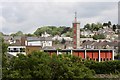
Maindee fire station
From the railway
Image: © Andrew Abbott
Taken: 25 May 2019
0.02 miles
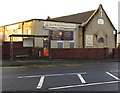
8
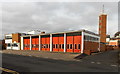
Maindee Fire Station and training tower, Newport
Located on the north side of Archibald Street, between Tweedy Lane on the right and Eveswell Street on the left. Part of the South Wales Fire and Rescue Service, this is one of three fire stations in the city.
Maindee Fire Station serves areas in the eastern side of the city, including Ringland, Alway, Liswerry and Somerton. Many industrial premises are located within the station's area, including the chemical site Solutia, gas cylinder supplier Flogas and several major hotels.
The station, built on a site that was bombed during the Second World War, was officially opened in 1960.
Image: © Jaggery
Taken: 5 Jan 2013
0.04 miles
9
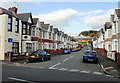
Rosslyn Road, Newport
Viewed from Conway Road.
Image: © Jaggery
Taken: 28 Oct 2009
0.04 miles
10
Seventh-day Adventist Church, Newport
On the south side of Chepstow Road, between Rosslyn Road and Tweedy Lane, opposite Eveswell Primary School.
Image: © Jaggery
Taken: 23 Dec 2015
0.05 miles