1
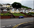
Bungalows above Chepstow Road, Newport
Derived from a Hindi word meaning in the style of Bengal, bungalow was originally used in English for a lightly-built house, with a veranda and one storey. In current UK usage it is a convenient word for any one-storey dwelling.
Image: © Jaggery
Taken: 21 Jun 2019
0.10 miles
2
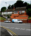
Chepstow Road bungalows, Newport
Bungalows above the north side of Chepstow Road viewed from the corner of Aberthaw Road.
The two-storey houses in the background are on the south side of Lawrence Hill Avenue.
Image: © Jaggery
Taken: 2 Jul 2016
0.10 miles
3
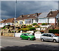
Bungalows above Chepstow Road, Newport
Above the north side of Chepstow Road viewed from the corner of Aberthaw Road.
The two-storey houses in the background are on the south side of Lawrence Hill Avenue.
Image: © Jaggery
Taken: 2 Jul 2016
0.10 miles
4
Polygon leak detection van, Chepstow Road, Newport
Parked opposite the Aberthaw Road junction.
Polygon UK is based in Blackstone Road, Huntingdon, Cambridgeshire.
Image: © Jaggery
Taken: 2 Jul 2016
0.11 miles
5
Junction of Chepstow Road and Aberthaw Road, Newport
Aberthaw Road from the left joins Chepstow Road. A sign near the van
on the right points along Aberthaw Road towards the Alway area of Newport.
Image: © Jaggery
Taken: 2 Jul 2016
0.11 miles
6
Junction of Aberthaw Road and Chepstow Road, Newport
Aberthaw Road from the Alway area of Newport ends at the B4237 Chepstow Road junction.
Image: © Jaggery
Taken: 2 Jul 2016
0.12 miles
7
Rooftop solar panels, Chepstow Road, Newport
Optimally located on a south-facing roof.
Image: © Jaggery
Taken: 21 Jun 2019
0.12 miles
8
Somerton Place, Newport
Though located on Chepstow Road, immediately east of the Aberthaw Road junction, these 2 terraced blocks, containing 16 houses, have retained the street name Somerton Place. The same applies to Bolts Row, http://www.geograph.org.uk/photo/1680263 located immediately east of Somerton Place. A small part of Bolts Row is visible in the distance, two buildings with their roofs orientated at 90 degrees to those in Somerton Place.
Image: © Jaggery
Taken: 24 Jan 2010
0.12 miles
9
UK's most powerful Wi-Fi signal advert, Aberthaw Road, Newport
On July 2nd 2016, one of three adverts on display on the JCDecaux site is for BT.
JCDecaux is the largest outdoor advertising corporation in the world.
Image: © Jaggery
Taken: 2 Jul 2016
0.12 miles
10
Christchurch Road approaching the post office
Looking east along Christchurch Road. The post office http://www.geograph.org.uk/photo/1720216 is on the right in the middle distance.
Image: © Jaggery
Taken: 24 Sep 2009
0.13 miles


