IMAGES TAKEN NEAR TO
St. Julians Road, NEWPORT, NP19 7RZ
Introduction
This page details the photographs taken nearby to St. Julians Road, NP19 7RZ by members of the Geograph project.
The Geograph project started in 2005 with the aim of publishing, organising and preserving representative images for every square kilometre of Great Britain, Ireland and the Isle of Man.

There are currently over 7.5m images from over14,400 individuals and you can help contribute to the project by visiting https://www.geograph.org.uk
Image Map
Images are licensed for reuse under creativecommons.org/licenses/by-sa/2.0
Notes
- Clicking on the map will re-center to the selected point.
- The higher the marker number, the further away the image location is from the centre of the postcode.
Image Listing (89 Images Found)
Images are licensed for reuse under creativecommons.org/licenses/by-sa/2.0
Image
Details
Distance
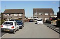
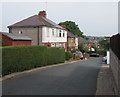
1
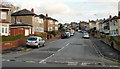
Firbank Avenue, Newport
Viewed from St Julians Road.
Image: © Jaggery
Taken: 1 Nov 2009
0.03 miles
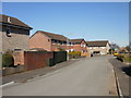
2
Firbank Crescent, Newport
Viewed from Firbank Avenue.
Image: © Jaggery
Taken: 1 Nov 2009
0.03 miles
3
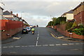
Wide St Julians Road, Newport
The suburban unclassified St Julians Road is here wide enough for a 5 metre
wide grass strip between the carriageways. The Firbank Avenue junction is on the right.
Image: © Jaggery
Taken: 10 Jun 2016
0.03 miles
4
Tree above a St Julians Road bus stop and shelter, Newport
This side of the road for buses towards the city centre.
Image: © Jaggery
Taken: 10 Jun 2016
0.04 miles
5
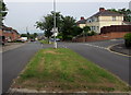
The far end of Lundy Drive, St Julians, Newport
Lundy Drive is the longest road in an area named after British islands. The other 'island' roads all connect with it. The other end of Lundy Drive connects with St Julians Road.
Image: © Jaggery
Taken: 4 Mar 2010
0.05 miles
6
Raphael Close, Newport
Viewed from Firbank Avenue
Image: © Jaggery
Taken: 20 Aug 2009
0.05 miles
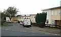
7
Telecoms cabinets and an electricity substation, Christchurch Road, Newport
Telecoms cabinets on the left, electricity substation http://www.geograph.org.uk/photo/4991917 on the right.
Image: © Jaggery
Taken: 10 Jun 2016
0.05 miles
8
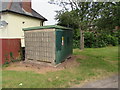
Christchurch Road electricity substation Newport
The Western Power Distribution electricity substation is set back from the north side of Christchurch Road, http://www.geograph.org.uk/photo/4991937 45 metres west of the St Julians Road junction. Its identifier is CLEVEDON RD. NEWPORT S/S No 532478 which is confusing as the nearest part of Clevedon Road is 100 metres away.
Image: © Jaggery
Taken: 10 Jun 2016
0.05 miles
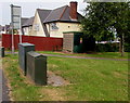
9
Northumberland Road, Newport
Northumberland Road descends from the north side of Christchurch Road towards Cardigan Place. http://www.geograph.org.uk/photo/1739326
Image: © Jaggery
Taken: 10 Jun 2016
0.06 miles
10
Westray Close, St Julians, Newport
Viewed from the corner of Lundy Drive. Streets in this area are named after British islands.
Image: © Jaggery
Taken: 4 Mar 2010
0.06 miles