IMAGES TAKEN NEAR TO
Brecon Road, NEWPORT, NP19 7RW
Introduction
This page details the photographs taken nearby to Brecon Road, NP19 7RW by members of the Geograph project.
The Geograph project started in 2005 with the aim of publishing, organising and preserving representative images for every square kilometre of Great Britain, Ireland and the Isle of Man.

There are currently over 7.5m images from over14,400 individuals and you can help contribute to the project by visiting https://www.geograph.org.uk
Image Map
Images are licensed for reuse under creativecommons.org/licenses/by-sa/2.0
Notes
- Clicking on the map will re-center to the selected point.
- The higher the marker number, the further away the image location is from the centre of the postcode.
Image Listing (119 Images Found)
Images are licensed for reuse under creativecommons.org/licenses/by-sa/2.0
Image
Details
Distance
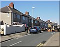
1
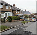
Houses on the west side of Brecon Road, St Julians, Newport
The view looking away from the recreation area http://www.geograph.org.uk/photo/1725491 towards St Julians Road.
Image: © Jaggery
Taken: 25 Feb 2010
0.05 miles
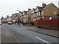
2
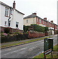
Houses on the east side of Brecon Road, St Julians, Newport
Viewed from the corner of St Julians Road.
Image: © Jaggery
Taken: 25 Feb 2010
0.05 miles
3
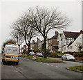
Tree cutting on St Julians Road, Newport
Taking advantage of calm weather, tree cutters are at work on the central reservation of St Julians Road. The silhouettes of two cutters can be seen in the branches of the tree behind the Road Narrows sign.
Image: © Jaggery
Taken: 25 Feb 2010
0.07 miles
4
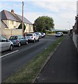
Radnor Road, Newport
Looking north along Radnor Road from the corner of Christchurch Road.
Image: © Jaggery
Taken: 7 Aug 2018
0.07 miles
5
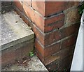
Ordnance Survey Cut Mark
This OS cut mark can be found on No96 St Julians Road. It marks a point 54.489m above mean sea level.
Image: © Adrian Dust
Taken: 9 Jun 2018
0.08 miles
6
Norfolk Road, St Julians, Newport
Houses on the west side of Norfolk Road, viewed from the St Julians Road end.
Image: © Jaggery
Taken: 25 Feb 2010
0.08 miles
7
Norfolk Road, Newport
Houses on the west side of the road, viewed from near the corner of Christchurch Road.
Image: © Jaggery
Taken: 4 Mar 2010
0.08 miles
8
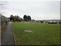
Recreation area, Summerhill, Newport
Located on the edge of the St Julians and Summerhill areas of Newport, viewed from the Brecon Road side. The path on the left runs between the edge of Radnor Road allotments, and a grassed area and children's play area.
Image: © Jaggery
Taken: 25 Feb 2010
0.09 miles
9
Entrance to Radnor Road allotments, Newport
Radnor Road is behind the camera. The path along the edge of the allotments leads to Brecon Road.
Image: © Jaggery
Taken: 25 Feb 2010
0.09 miles
10
Southern end of Norfolk Road, Newport
Looking north along Norfolk Road from the corner of Christchurch Road.
Image: © Jaggery
Taken: 7 Aug 2018
0.09 miles