IMAGES TAKEN NEAR TO
Chichester Close, NEWPORT, NP19 7LJ
Introduction
This page details the photographs taken nearby to Chichester Close, NP19 7LJ by members of the Geograph project.
The Geograph project started in 2005 with the aim of publishing, organising and preserving representative images for every square kilometre of Great Britain, Ireland and the Isle of Man.

There are currently over 7.5m images from over14,400 individuals and you can help contribute to the project by visiting https://www.geograph.org.uk
Image Map
Images are licensed for reuse under creativecommons.org/licenses/by-sa/2.0
Notes
- Clicking on the map will re-center to the selected point.
- The higher the marker number, the further away the image location is from the centre of the postcode.
Image Listing (50 Images Found)
Images are licensed for reuse under creativecommons.org/licenses/by-sa/2.0
Image
Details
Distance
1
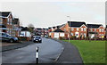
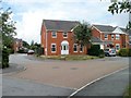
Chichester Close, Newport
1990s housing development close to the River Usk.
Image: © Jaggery
Taken: 17 Dec 2009
0.03 miles
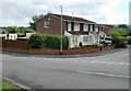
2
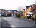
Clipper Close, Newport
Viewed from Chichester Close. Part of a 1990s housing development close to the River Usk.
Image: © Jaggery
Taken: 17 Dec 2009
0.06 miles
3
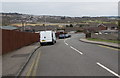
Down to the Moorings, St Julians, Newport
The road descends from the B4596 Caerleon Road towards houses in the Moorings,
an area of flat land on the south side of a loop in the River Usk.
Image: © Jaggery
Taken: 22 Mar 2016
0.07 miles
4
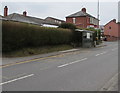
Caerleon Road bus stop and shelter near the Old Barn Estate, Newport
This side of the road for buses to the city centre.
Image: © Jaggery
Taken: 22 Mar 2016
0.11 miles
5
Corner of Clipper Close and Cutter Close, Newport
Houses built in the 1990s, close to the River Usk. Cutter Close http://www.geograph.org.uk/photo/1975645 is on the left.
Image: © Jaggery
Taken: 22 Jul 2010
0.11 miles
6
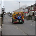
Scarab on Caerleon Road, Newport
A Newport City Council left-hand drive Scarab street cleaning vehicle is at work on Caerleon Road in March 2016.
Image: © Jaggery
Taken: 22 Mar 2016
0.12 miles
7
Eastern spur of The Moorings, Newport
The Moorings is a residential street extending eastwards from Haisbro Avenue to Chichester Close, where the road bends in an arc from heading east to heading west. Near the eastern edge of the arc are a few houses, some of which are seen here. A few metres beyond the left edge of the view is the start of Chichester Close. http://www.geograph.org.uk/photo/1623008
Image: © Jaggery
Taken: 22 Jul 2010
0.12 miles
8
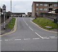
Junction of Old Barn and Caerleon Road, Newport
The road named Old Barn ascends from the south side of the B4596 Caerleon Road into the Old Barn Estate.
The sign on the left shows that no vehicles heavier than 7.5 tonnes are allowed in Old Barn between 11pm and 7am. Double yellow lines on both sides of Old Barn indicate no parking at any time.
Image: © Jaggery
Taken: 22 Mar 2016
0.12 miles
9
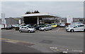
St Julians Car Sales, Newport
On the north side of Caerleon Road, opposite the Beaufort Road junction.
Image: © Jaggery
Taken: 22 Mar 2016
0.13 miles
10
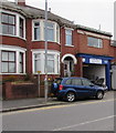
D and S Car Repairs, Caerleon Road, Newport
Business at 460 Caerleon Road.
Image: © Jaggery
Taken: 22 Mar 2016
0.13 miles