1
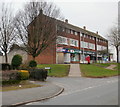
Elaine Crescent (2), St Julians, Newport
The western end and eastern end of Elaine Crescent connect with Heather Road.
The ends are about 100 metres apart. This view is of houses at the eastern end, viewed from Heather Road.
Image: © Jaggery
Taken: 4 Mar 2010
0.04 miles
2
Looking down Heather Road, Newport
On the left is Merlin Crescent; on the right is Rembrandt Way. http://www.geograph.org.uk/photo/1720201
Just visible in the middle of the high ground in the far distance is Twmbarlwm
Image
Image: © Jaggery
Taken: 24 Sep 2009
0.04 miles
3
Eastern end of Merlin Crescent, St Julians, Newport
Houses on the west side of Merlin Crescent, viewed from the corner of Avalon Drive.
Image: © Jaggery
Taken: 4 Mar 2010
0.07 miles
4
Heather Road climbs towards the Rembrandt Way junction
Houses on the south side of Heather Road viewed from near the junction with the eastern end of Elaine Crescent. The tree in the distance is opposite the Rembrandt Way turning.
Image: © Jaggery
Taken: 4 Mar 2010
0.07 miles
5
Rembrandt Way, Newport
Viewed from the corner of Heather Road.
Image: © Jaggery
Taken: 24 Sep 2009
0.08 miles
6
Hogarth Close, Newport
Houses on the north side of Hogarth Close are set about a metre below the level of the pavement. On the far side of the houses, behind screening trees, is the M4 motorway. This view is from the corner of Rembrandt Way.
Image: © Jaggery
Taken: 7 Feb 2010
0.10 miles
7
Corner of Merlin Crescent and Heather Road, St Julians, Newport
The western end of Merlin Crescent joins Heather Road (in the foreground).
Merlin Crescent rejoins Heather Road about 250 metres to the east (left) of this corner.
Image: © Jaggery
Taken: 4 Mar 2010
0.10 miles
8
The Centurion, St Julians, Newport
Pub on Heather Road, adjacent to the block of shops. http://www.geograph.org.uk/photo/1703764
Image: © Jaggery
Taken: 7 Feb 2010
0.11 miles
9
St Julians post office, Newport
At 86 Heather Road, in a block of shops that includes, from left to right :
An empty property, formerly Coral bookmakers.
St Julians post office.
Beauty Salon.
Heather Stores.
Image: © Jaggery
Taken: 7 Feb 2010
0.11 miles
10
Elaine Crescent (1), St Julians, Newport
The western end and eastern end of Elaine Crescent connect with Heather Road.
The ends are about 100 metres apart. This view is of houses on the north side of the crescent, viewed from near the western end.
Image: © Jaggery
Taken: 4 Mar 2010
0.12 miles


