1
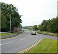
High Bank, Newport
Viewed from Bank Street
Image: © Jaggery
Taken: 2 Aug 2009
0.03 miles
2
Motorway slip road, Caerleon Road, Newport
Straight ahead for the westbound M4, or take the roundabout for the St Julians area of Newport, or for Caerleon. This is the southwest part of M4 motorway junction 25.
Image: © Jaggery
Taken: 6 Sep 2009
0.03 miles
3
Headquarters of the 6th Newport Scout Group
The building is set back about 20 metres from Bank Street and protected by railings. HQ of the 6th Newport Scout Group which was formed on October 17 1922 and is the oldest Scout Group in Newport
Image: © Jaggery
Taken: 2 Aug 2009
0.04 miles
4
The road to Cwmbran
Traffic for Cwmbran is signed to leave the M4 at Junction 25, and then joins a road which runs alongside the M4 over the River Usk. There is access from the motorway to this road at Junction 25A, but the route is signed at Junction 25 because of the awkwardness of leaving at Junction 25A
Image: © David Smith
Taken: 6 Jul 2011
0.04 miles
5
Bank Street electricity substation, Newport
The identifier on the Western Power Distribution electricity substation is
BANK ST NEWPORT S/S NO 532515.
White on red notices show NO PARKING. 24 HOUR ACCESS REQUIRED.
A Scout building is in the background. http://www.geograph.org.uk/photo/1427751
Image: © Jaggery
Taken: 27 Nov 2014
0.05 miles
6
Corner of Durham Road and Bank Street, Newport
Viewed from Bank Street. A one-way traffic system, away from the camera, is in force along Durham Road ahead. This is the northern end of Durham Road which extends south for 670 metres,
to the junction of Constance Street, near the Caerleon Road junction.
Image: © Jaggery
Taken: 27 Nov 2014
0.06 miles
7
Bank Street houses, Newport
Row of five houses located between Bank Lane and High Bank.
Image: © Jaggery
Taken: 30 Mar 2016
0.06 miles
8
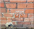
Ordnance Survey Cut Mark
This OS cut mark can be found on a garage SW side of Bank street. It marks a point 15.866m above mean sea level.
Image: © Adrian Dust
Taken: 9 Jun 2018
0.06 miles
9
Scarborough Road, Newport
Viewed from the junction with Stockton Road.
Image: © Jaggery
Taken: 2 Aug 2009
0.07 miles
10
Darlington Court, Newport
Modern housing on Darlington Court, viewed from the Bank Street end.
Image: © Jaggery
Taken: 31 Jan 2010
0.07 miles


