IMAGES TAKEN NEAR TO
Harrogate Road, NEWPORT, NP19 7JH
Introduction
This page details the photographs taken nearby to Harrogate Road, NP19 7JH by members of the Geograph project.
The Geograph project started in 2005 with the aim of publishing, organising and preserving representative images for every square kilometre of Great Britain, Ireland and the Isle of Man.

There are currently over 7.5m images from over14,400 individuals and you can help contribute to the project by visiting https://www.geograph.org.uk
Image Map
Images are licensed for reuse under creativecommons.org/licenses/by-sa/2.0
Notes
- Clicking on the map will re-center to the selected point.
- The higher the marker number, the further away the image location is from the centre of the postcode.
Image Listing (133 Images Found)
Images are licensed for reuse under creativecommons.org/licenses/by-sa/2.0
Image
Details
Distance
1
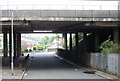
Under the M4 to Stockton Close
Viewed from Stockton Road ; in the distance is Stockton Close. The bridge carries the M4 motorway - junctions 25 and 25A are nearby.
Image: © Jaggery
Taken: 2 Aug 2009
0.03 miles
2
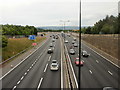
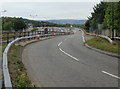
Westbound M4 motorway, Caerleon Road, Newport
Viewed from the Caerleon Road roundabout, the M4 motorway heads away from junction 25. The next junction in this direction is 26, Malpas.
There is no slip road from the motorway for eastbound traffic here. The slip road on the right is from the A4042, which has followed a route parallel with the M4 for about a kilometre, from the Grove Park roundabout.
Image: © Jaggery
Taken: 11 Jul 2010
0.03 miles
3
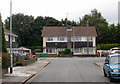
Harrogate Road, Newport
Harrogate Road is a short cul-de-sac off Scarborough Road. A few metres behind the house at the end of the road, screened by trees, is the M4 motorway.
Image: © Jaggery
Taken: 16 Aug 2009
0.04 miles
4
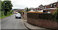
Stockton Close, Newport
In this section of Stockton Close, houses are along the north side only. On the other side of the road are shrubs and trees, part of which can be seen in the upper left of the photo. This vegetation screens the Close from the M4 motorway and B4596, which briefly run alongside each other and parallel with Stockton Close.
Image: © Jaggery
Taken: 16 Aug 2009
0.06 miles
5
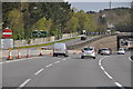
Slip road onto Caerleon Road, Newport
Viewed from the edge of Caerleon Road.
Although this spot is adjacent to M4 motorway junction 25, there is no exit here for eastbound vehicles. The slip road is from the A4042, which has followed a path parallel with the M4 from Grove Park roundabout, for about a kilometre.
Image: © Jaggery
Taken: 11 Jul 2010
0.06 miles
6
Newport : The M4 Motorway
The M4 Motorway heading eastbound as it passes through the Newport area and junction 25A.
Image: © Lewis Clarke
Taken: 11 Apr 2014
0.06 miles
7
Main line north from Bank Street bridge
In the distance a bridge carries the M4 motorway across the railway. The line heads north towards Cwmbran.
Image: © Jaggery
Taken: 24 Sep 2009
0.08 miles
8
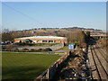
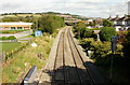
The view north from the Bank Street railway bridge, Newport
The eastern edge of The Glebelands is on the left : in view are the Newport Indoor Bowls Centre building http://www.geograph.org.uk/photo/1505309 and part of an outdoor bowls green. On the right, the railway track heads towards Cwmbran station and The North. The concrete bridge over the railway carries the M4 motorway.
Image: © Jaggery
Taken: 7 Mar 2010
0.08 miles
9
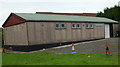
Headquarters of the 6th Newport Scout Group
The building is set back about 20 metres from Bank Street and protected by railings. HQ of the 6th Newport Scout Group which was formed on October 17 1922 and is the oldest Scout Group in Newport
Image: © Jaggery
Taken: 2 Aug 2009
0.09 miles
10
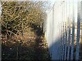
Path from The Glebelands to Stockton Close
The narrow, muddy path is beside the railway boundary railings along the northeast edge of the Glebelands. Ahead, the path passes under the railway http://www.geograph.org.uk/photo/1752194 and ends at Stockton Close.
Image: © Jaggery
Taken: 7 Mar 2010
0.09 miles