IMAGES TAKEN NEAR TO
Durham Road, NEWPORT, NP19 7HT
Introduction
This page details the photographs taken nearby to Durham Road, NP19 7HT by members of the Geograph project.
The Geograph project started in 2005 with the aim of publishing, organising and preserving representative images for every square kilometre of Great Britain, Ireland and the Isle of Man.

There are currently over 7.5m images from over14,400 individuals and you can help contribute to the project by visiting https://www.geograph.org.uk
Image Map
Images are licensed for reuse under creativecommons.org/licenses/by-sa/2.0
Notes
- Clicking on the map will re-center to the selected point.
- The higher the marker number, the further away the image location is from the centre of the postcode.
Image Listing (160 Images Found)
Images are licensed for reuse under creativecommons.org/licenses/by-sa/2.0
Image
Details
Distance
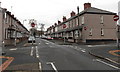
1
Durham Road , Newport
Looking south along Durham Road from its junction with Bank Street
Image: © Jaggery
Taken: 2 Aug 2009
0.03 miles
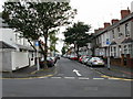
2
Corner of Durham Road and Bank Street, Newport
Viewed from Bank Street. A one-way traffic system, away from the camera, is in force along Durham Road ahead. This is the northern end of Durham Road which extends south for 670 metres,
to the junction of Constance Street, near the Caerleon Road junction.
Image: © Jaggery
Taken: 27 Nov 2014
0.03 miles
3
Six No Entry signs in Newport
At the crossroads of Durham Road and Oak Street. No entry to Oak Street (left or right) or Durham Road ahead. The scene is not as nightmarish as it appears. No Entry signs at the Stafford Road junction 150 metres behind the camera should have prevented vehicles reaching this location in this direction.
Image: © Jaggery
Taken: 27 Nov 2014
0.04 miles
4
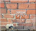
Ordnance Survey Cut Mark
This OS cut mark can be found on a garage SW side of Bank street. It marks a point 15.866m above mean sea level.
Image: © Adrian Dust
Taken: 9 Jun 2018
0.04 miles
5
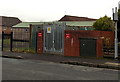
Bank Street electricity substation, Newport
The identifier on the Western Power Distribution electricity substation is
BANK ST NEWPORT S/S NO 532515.
White on red notices show NO PARKING. 24 HOUR ACCESS REQUIRED.
A Scout building is in the background. http://www.geograph.org.uk/photo/1427751
Image: © Jaggery
Taken: 27 Nov 2014
0.05 miles
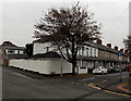
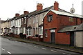
6
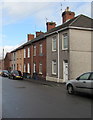
Bank Street houses, Newport
Row of five houses located between Bank Lane and High Bank.
Image: © Jaggery
Taken: 30 Mar 2016
0.05 miles
7
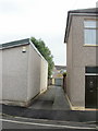
Bank Lane, Newport
Several lanes run between the backs of houses in this area of Newport, between Caerleon Road and the Glebelands. This one is Bank Lane, heading away from Bank Street, towards Oak Street.
Image: © Jaggery
Taken: 11 Jul 2010
0.05 miles
8
Scarborough Road, Newport
Viewed from the junction with Stockton Road.
Image: © Jaggery
Taken: 2 Aug 2009
0.05 miles
9
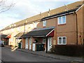
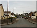
Darlington Court, Newport
Modern housing on Darlington Court, viewed from the Bank Street end.
Image: © Jaggery
Taken: 31 Jan 2010
0.05 miles
10
Monumental sculptors in Oak Street, Newport
Premises of E.L.Thomas, 17A Oak Street.
Image: © Jaggery
Taken: 27 Nov 2014
0.05 miles