IMAGES TAKEN NEAR TO
Stockton Close, NEWPORT, NP19 7HH
Introduction
This page details the photographs taken nearby to Stockton Close, NP19 7HH by members of the Geograph project.
The Geograph project started in 2005 with the aim of publishing, organising and preserving representative images for every square kilometre of Great Britain, Ireland and the Isle of Man.

There are currently over 7.5m images from over14,400 individuals and you can help contribute to the project by visiting https://www.geograph.org.uk
Image Map
Images are licensed for reuse under creativecommons.org/licenses/by-sa/2.0
Notes
- Clicking on the map will re-center to the selected point.
- The higher the marker number, the further away the image location is from the centre of the postcode.
Image Listing (114 Images Found)
Images are licensed for reuse under creativecommons.org/licenses/by-sa/2.0
Image
Details
Distance
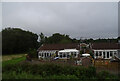
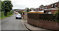
2
Houses on Stockton Close
In Malpas, Newport. From the railway.
Image: © Andrew Abbott
Taken: 25 May 2019
0.07 miles
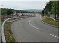
3
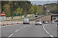
Newport : The M4 Motorway
The M4 Motorway heading eastbound as it passes through the Newport area and junction 25A.
Image: © Lewis Clarke
Taken: 11 Apr 2014
0.07 miles
4
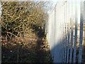
Path from The Glebelands to Stockton Close
The narrow, muddy path is beside the railway boundary railings along the northeast edge of the Glebelands. Ahead, the path passes under the railway http://www.geograph.org.uk/photo/1752194 and ends at Stockton Close.
Image: © Jaggery
Taken: 7 Mar 2010
0.08 miles
5
Stockton Close, Newport
In this section of Stockton Close, houses are along the north side only. On the other side of the road are shrubs and trees, part of which can be seen in the upper left of the photo. This vegetation screens the Close from the M4 motorway and B4596, which briefly run alongside each other and parallel with Stockton Close.
Image: © Jaggery
Taken: 16 Aug 2009
0.08 miles
6
Slip road onto Caerleon Road, Newport
Viewed from the edge of Caerleon Road.
Although this spot is adjacent to M4 motorway junction 25, there is no exit here for eastbound vehicles. The slip road is from the A4042, which has followed a path parallel with the M4 from Grove Park roundabout, for about a kilometre.
Image: © Jaggery
Taken: 11 Jul 2010
0.08 miles
8
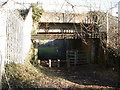
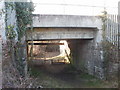
Path from Glebelands reaches a railway bridge, Newport
A path http://www.geograph.org.uk/photo/1752178 from The Glebelands crosses under the Newport to Cwmbran and The North railway.
On the other side of the bridge is Stockton Close. The view from the opposite side of the bridge. http://www.geograph.org.uk/photo/1752205
Image: © Jaggery
Taken: 7 Mar 2010
0.09 miles
9
Stockton Close railway bridge, Newport
Looking from the edge of Stockton Close towards the railway bridge over a path from The Glebelands. The view from the opposite side. http://www.geograph.org.uk/photo/1752194
Image: © Jaggery
Taken: 7 Mar 2010
0.09 miles
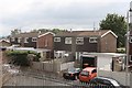
10
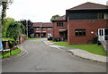
Croydon Court, Newport
Viewed from Croydon Close.
Image: © Jaggery
Taken: 16 Aug 2009
0.09 miles