IMAGES TAKEN NEAR TO
Durham Road, NEWPORT, NP19 7FP
Introduction
This page details the photographs taken nearby to Durham Road, NP19 7FP by members of the Geograph project.
The Geograph project started in 2005 with the aim of publishing, organising and preserving representative images for every square kilometre of Great Britain, Ireland and the Isle of Man.

There are currently over 7.5m images from over14,400 individuals and you can help contribute to the project by visiting https://www.geograph.org.uk
Image Map
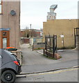
Images are licensed for reuse under creativecommons.org/licenses/by-sa/2.0
Notes
- Clicking on the map will re-center to the selected point.
- The higher the marker number, the further away the image location is from the centre of the postcode.
Image Listing (273 Images Found)
Images are licensed for reuse under creativecommons.org/licenses/by-sa/2.0
Image
Details
Distance
1
Farm Lane, Newport
Today merely a small, dead-end lane on the north side of York Road, Farm Lane is of historical interest. It is a remnant of a lane to Duckpool Farm. The farm disappeared in the middle of the 19th century when houses were built in the area.
Another reminder of the former farm is in the name of nearby Duckpool Road.
Image: © Jaggery
Taken: 11 Apr 2010
0.00 miles
2

Fortune House, Newport
Durham Road Chinese takeaway on the corner of York Road.
Image: © Jaggery
Taken: 27 Nov 2014
0.01 miles
3
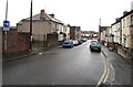
York Road, Newport
York Road extends for 80 metres from Caerleon Road (behind the camera) to Durham Road.
The sign on the left shows that a one-way traffic system is in force along York Road.
Image: © Jaggery
Taken: 30 Mar 2016
0.01 miles
4
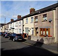
York Road houses, Newport
On the north side of York Road between Caerleon Road and Durham Road.
Image: © Jaggery
Taken: 6 Oct 2017
0.02 miles
5
York Road premises of E.J. Herbert & Son Memorials, Newport
On the corner of York Road and Morden Lane. The name sign on the wall states
that the business's office and showroom is at 123 Corporation Road, Newport.
Image: © Jaggery
Taken: 30 Mar 2016
0.02 miles
6
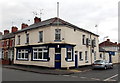
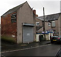
St Julians Conservative and Unionist Club, Newport
Located at 37-39 Durham Road, on the corner of Elysia Street.
Image: © Jaggery
Taken: 1 Mar 2013
0.03 miles
7
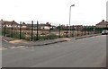
Fenced-off site of the demolished former Durham Road school, Newport
Viewed from the corner of Durham Road and Elysia Street on March 1st 2013.
This was the location of Durham Road School http://www.geograph.org.uk/photo/1693048 which closed at the end of 2009. Pupils and staff transferred to the nearby newly-built Glan Usk school, http://www.geograph.org.uk/photo/1934876 which opened in January 2010. The new school was a long-awaited replacement for the Victorian buildings, which had been declared unfit for purpose more than a decade earlier.
There was no indication on the fencing of the future use of this vacant area.
Image: © Jaggery
Taken: 1 Mar 2013
0.04 miles
8
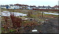
Site of demolished Durham Road School, Newport
Viewed through a fence surrounding the site, from the corner of Durham Road and Durham Lane in late November 2014. This was the location of Durham Road School http://www.geograph.org.uk/photo/1693048 which closed at the end of 2009. Pupils and staff transferred to the nearby newly-built Glan Usk school, http://www.geograph.org.uk/photo/1934876 which opened in January 2010. The new school was a long-awaited replacement for the Victorian buildings, which had been declared unfit for purpose more than a decade earlier. There was no indication on the fencing of the future use of this site.
Image: © Jaggery
Taken: 27 Nov 2014
0.04 miles
9
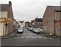
York Road, Newport
Looking east from Durham Road along York Road towards Caerleon Road.
Fortune House http://www.geograph.org.uk/photo/4260548 is on the left.
Image: © Jaggery
Taken: 27 Nov 2014
0.05 miles
10
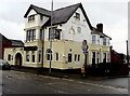
The Victoria, Caerleon Road, Newport
Recently refurbished pub on the corner of Caerleon Road and York Road, viewed in late March 2016.
Here's http://www.geograph.org.uk/photo/1463084 how it looked in August 2009.
http://www.geograph.org.uk/photo/4886361 to a closer view of the Penny Black name sign.
Image: © Jaggery
Taken: 30 Mar 2016
0.06 miles