IMAGES TAKEN NEAR TO
East Usk Road, NEWPORT, NP19 7AG
Introduction
This page details the photographs taken nearby to East Usk Road, NP19 7AG by members of the Geograph project.
The Geograph project started in 2005 with the aim of publishing, organising and preserving representative images for every square kilometre of Great Britain, Ireland and the Isle of Man.

There are currently over 7.5m images from over14,400 individuals and you can help contribute to the project by visiting https://www.geograph.org.uk
Image Map
Images are licensed for reuse under creativecommons.org/licenses/by-sa/2.0
Notes
- Clicking on the map will re-center to the selected point.
- The higher the marker number, the further away the image location is from the centre of the postcode.
Image Listing (903 Images Found)
Images are licensed for reuse under creativecommons.org/licenses/by-sa/2.0
Image
Details
Distance
1
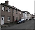
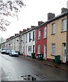
East Usk Road houses, Newport
Houses on the east side of the road, viewed from the corner of Riverside.
Image: © Jaggery
Taken: 19 Jan 2017
0.01 miles
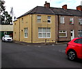
2
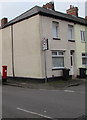
Lullabyz Nursery, Newport
Located on the corner of East Usk Road and Tregare Street, Lullabyz Nursery opened in 2012.
It is a private day care nursery for children aged from 6 weeks to 8 years.
Image: © Jaggery
Taken: 25 Nov 2012
0.01 miles
3
Corner of Bond Street and East Usk Road, Newport
The white car is parked near Skip Jennings Hall https://www.geograph.org.uk/photo/1671083 in East Usk Road.
Image: © Jaggery
Taken: 13 Jul 2020
0.01 miles
4
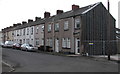
Row of houses, East Usk Road, Newport
Viewed in January 2017. A derelict building seen on the right
in an August 2014 Google Earth Street View has been demolished.
Image: © Jaggery
Taken: 19 Jan 2017
0.02 miles
5
West side of Rudry Street, Newport
Houses on the west side of the street viewed looking towards Tregare Street.
Image: © Jaggery
Taken: 25 Nov 2012
0.02 miles
6
Queen Elizabeth II pillarbox, Tregare Street, Newport
Near the corner of Rudry Street.
Image: © Jaggery
Taken: 19 Jan 2017
0.02 miles
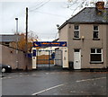
7
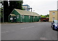
June 23rd 2016 polling station in Skip Jennings Hall, East Usk Road, Newport
The corrugated metal building is in use today as a polling station for the June 23rd 2016 UK EU Referendum.
The polling station is open from 7am until 10pm.
Image: © Jaggery
Taken: 23 Jun 2016
0.02 miles
8
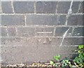
Ordnance Survey Cut Mark
This OS cut mark can be found on the NW angle of the railway bridge. It marks a point 8.572m above mean sea level.
Image: © Adrian Dust
Taken: 9 Jun 2018
0.03 miles
9
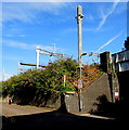
Electrification preparation on the eastern approach to Newport railway station
Recently-erected support structures for overhead electricity cables viewed from East Usk Road on August 7th 2018, part of the infrastructure for the electrification of the South Wales Main Line to Cardiff. Electric trains are scheduled to operate on this route from 2019 - exact start date not yet known.
Image: © Jaggery
Taken: 7 Aug 2018
0.04 miles
10
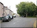
Tregare Street trees, Newport
There are no houses on the south side of Tregare Street, viewed here from the corner of East Usk Road. Instead, a long row of trees separates the street from railway lines - the main line heading north to Hereford. The tracks on the other side of the trees form part of the Maindee Triangle, which is described here. http://www.geograph.org.uk/photo/1671050
Image: © Jaggery
Taken: 30 Aug 2009
0.04 miles