IMAGES TAKEN NEAR TO
Beading Close, NEWPORT, NP19 4TL
Introduction
This page details the photographs taken nearby to Beading Close, NP19 4TL by members of the Geograph project.
The Geograph project started in 2005 with the aim of publishing, organising and preserving representative images for every square kilometre of Great Britain, Ireland and the Isle of Man.

There are currently over 7.5m images from over14,400 individuals and you can help contribute to the project by visiting https://www.geograph.org.uk
Image Map
Images are licensed for reuse under creativecommons.org/licenses/by-sa/2.0
Notes
- Clicking on the map will re-center to the selected point.
- The higher the marker number, the further away the image location is from the centre of the postcode.
Image Listing (35 Images Found)
Images are licensed for reuse under creativecommons.org/licenses/by-sa/2.0
Image
Details
Distance
1
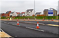
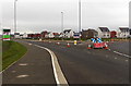
Parklands, Glan Llyn, Newport
Parklands at Glan Llyn is a Charles Church housing development on land formerly part of Llanwern Steelworks.
Image: © Jaggery
Taken: 7 Feb 2012
0.06 miles
2
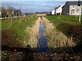
Drainage channel, Glan Llyn, Newport
Formerly part of Llanwern steelworks, this area is being converted to residential use.
Viewed in February 2012.
Image: © Jaggery
Taken: 8 Feb 2012
0.09 miles
3
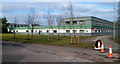
SE corner of former steelworks offices, Glan Llyn, Newport
The former Llanwern steelworks offices now appear to be in use for staff managing the major redevelopment project at Glan Llyn. http://www.geograph.org.uk/photo/2794519
Image: © Jaggery
Taken: 8 Feb 2012
0.10 miles
4
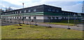
NE corner of former steelworks offices, Glan Llyn, Newport
The former Llanwern steelworks offices now appear to be in use for staff managing the major redevelopment project at Glan Llyn. http://www.geograph.org.uk/photo/2794519
Image: © Jaggery
Taken: 8 Feb 2012
0.10 miles
5
Greenacres and Parklands, Newport
Viewed from the edge of an A4810 roundabout in early January 2013. Houses are being built, or have recently been built, on land formerly part of Llanwern Steelworks. The board on the left is for the Persimmon Greenacres development. A Charles Church board on the right shows Parklands.
Image: © Jaggery
Taken: 8 Jan 2013
0.11 miles
6
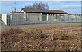
Former steelworks building, Glan Llyn, Newport
The single-storey building in a fenced enclosure was formerly near the western edge of the Llanwern steelworks site. The area, roughly 2km by 1km, is being redeveloped. http://www.geograph.org.uk/photo/2794519
Image: © Jaggery
Taken: 8 Feb 2012
0.11 miles
7
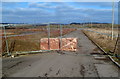
Slab of rock and fencing blocks road at the western edge of Glan Llyn
This area, formerly at the western edge of Llanwern steelworks, is being redeveloped as part of the Glan Llyn project. http://www.geograph.org.uk/photo/2794519
Image: © Jaggery
Taken: 8 Feb 2012
0.11 miles
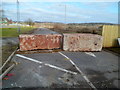
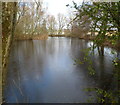
8
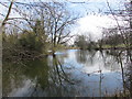
Reflections on a lake, Newport
Viewed from the path https://www.geograph.org.uk/photo/5719349 from Queen's Way to Spencer Way.
Image: © Jaggery
Taken: 27 Mar 2018
0.12 miles
9
No vehicles beyond this point, Glan Llyn, Newport
Glan Llyn is a major redevelopment project http://www.geograph.org.uk/photo/2794519 in the east of Newport, on the long-derelict area of land about 2km x 1km that was formerly the western section of Llanwern steelworks. Two massive slabs of rock prevent vehicular access ahead. Fencing out of shot on the left prevents vehicles driving past the side of the slabs.
Image: © Jaggery
Taken: 8 Feb 2012
0.12 miles
10
Lake viewed from the roadway at the western edge of Glan Llyn, Newport
Formerly at the western edge of Llanwern steelworks, the area east of the lake is undergoing a major redevelopment. http://www.geograph.org.uk/photo/2794519
Image: © Jaggery
Taken: 8 Feb 2012
0.12 miles