IMAGES TAKEN NEAR TO
Churchward Drive, NEWPORT, NP19 4SF
Introduction
This page details the photographs taken nearby to Churchward Drive, NP19 4SF by members of the Geograph project.
The Geograph project started in 2005 with the aim of publishing, organising and preserving representative images for every square kilometre of Great Britain, Ireland and the Isle of Man.

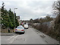
There are currently over 7.5m images from over14,400 individuals and you can help contribute to the project by visiting https://www.geograph.org.uk
Image Map
Images are licensed for reuse under creativecommons.org/licenses/by-sa/2.0
Notes
- Clicking on the map will re-center to the selected point.
- The higher the marker number, the further away the image location is from the centre of the postcode.
Image Listing (174 Images Found)
Images are licensed for reuse under creativecommons.org/licenses/by-sa/2.0
Image
Details
Distance
1
Far end of Libeneth Road, Newport
Beyond the eastern junction with Lime Crescent, on the left, the far end of Libeneth Road is a small parking area, with a few business premises. Further on, there is a pathhttp://www.geograph.org.uk/photo/1684446 to Liswerry Pond http://www.geograph.org.uk/photo/1589763 .
The fence on the right is the boundary of the South Wales main railway line.
Image: © Jaggery
Taken: 28 Jan 2010
0.03 miles
2
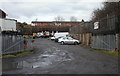
Bona's Scrap, Libeneth Road, Newport
Scrapyard located at the far end of Libeneth Road. Bona's Scrap handle MOT failures, write-offs and unwanted vehicles.
Image: © Jaggery
Taken: 28 Jan 2010
0.03 miles
3
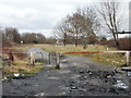
Start of a path to Liswerry Pond, Newport
Behind is Libeneth Road http://www.geograph.org.uk/photo/1684436. Ahead is a path to Liswerry Pond http://www.geograph.org.uk/photo/1589763.
Image: © Jaggery
Taken: 28 Jan 2010
0.03 miles
4
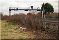
Railway signal gantry, Liswerry, Newport
Viewed from a path from Libeneth Road to Liswerry Pond. The signal gantry spans the South Wales main railway line.
Image: © Jaggery
Taken: 28 Jan 2010
0.03 miles
5
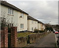
Libeneth Road approaching the eastern end of Lime Crescent, Newport
Houses on the north side of Libeneth Road, between the west and east junctions with Lime Crescent.
On the other side of the road is the South Wales main railway lime.
Image: © Jaggery
Taken: 28 Jan 2010
0.04 miles
6
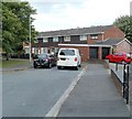
Newport MOT & Repair Centre, Libeneth Road
Located at the far end of Libeneth Road, next to the last house and set back several metres from the road.
Image: © Jaggery
Taken: 28 Jan 2010
0.04 miles
7
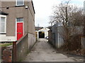
Far end of Churchward Drive, Newport
The South Wales main railway is behind the houses. The Drive is named after George Jackson Churchward. http://www.geograph.org.uk/photo/2549431
Image: © Jaggery
Taken: 10 Aug 2011
0.06 miles
8
Armstrong Close, Newport
The southern end of Armstrong Close viewed from Churchward Drive, to the east of Hawksworth Grove. The three streets are named after Chief Mechanical Engineers (CME) of the Great Western Railway (GWR). Joseph Armstrong (1816-1877) was the GWR's Locomotive, Carriage and Wagon Superintendent, (the equivalent of the 20th century post of CME) from 1864-1877.
See http://www.geograph.org.uk/photo/2549431 for details of the other two men.
Image: © Jaggery
Taken: 10 Aug 2011
0.07 miles
9
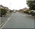
Churchward Drive, Newport
The view west from the eastern edge of the Drive, named after George Jackson Churchward. http://www.geograph.org.uk/photo/2549431
Image: © Jaggery
Taken: 10 Aug 2011
0.07 miles
10
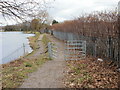
Western entrance gate to Liswerry Pond, Newport
The entrance gate is at the eastern end of a path from Libeneth Road. The path continues along the south side of the pond. On the other side of the path is the South Wales main railway line.
Image: © Jaggery
Taken: 28 Jan 2010
0.09 miles