IMAGES TAKEN NEAR TO
Decoypool Road, NEWPORT, NP19 4RG
Introduction
This page details the photographs taken nearby to Decoypool Road, NP19 4RG by members of the Geograph project.
The Geograph project started in 2005 with the aim of publishing, organising and preserving representative images for every square kilometre of Great Britain, Ireland and the Isle of Man.

There are currently over 7.5m images from over14,400 individuals and you can help contribute to the project by visiting https://www.geograph.org.uk
Image Map
Images are licensed for reuse under creativecommons.org/licenses/by-sa/2.0
Notes
- Clicking on the map will re-center to the selected point.
- The higher the marker number, the further away the image location is from the centre of the postcode.
Image Listing (9 Images Found)
Images are licensed for reuse under creativecommons.org/licenses/by-sa/2.0
Image
Details
Distance
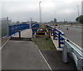
1
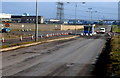
Western entrance to Llanwern Steelworks
This view was taken in February 2012, when there was a guard's hut and barriers across the road.
Since then, the guard's hut and barriers have gone following a major upgrade of the road which was a private road in this view. It is now a public road, the A4810 to Magor. The steelworks entrance is now from the eastern (Magor) side.
Image: © Jaggery
Taken: 8 Feb 2012
0.14 miles
2
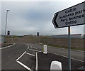
Access road to Celtic Business Park, Newport
Viewed from the A4810. Celtic Business Park is a major new 100 acre industrial and warehousing scheme in the east of Newport, on a brownfield regeneration site. The land was formerly part of Llanwern Steelworks. At the early September 2013 date of this view, the signs are in place for the yet-to-be built business park, which will be adjacent to the Glan Llyn residential scheme, where houses are being built. When complete, the combined schemes will provide c4,000 new homes and more than 1.5 million square feet of new employment space.
Image: © Jaggery
Taken: 3 Sep 2013
0.16 miles
3
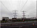
Twin pylons in Llanwern Steelworks
Power lines cross over the A4810 and enter the steelworks.
Image: © Jaggery
Taken: 3 Sep 2013
0.18 miles
4
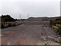
Industrial waste, Llanwern
Viewed from the A4810. This land used to be part of the huge Llanwern Steelworks site. The steelworks now (2013) occupies a much reduced, though still large, site on the north side of the A4810.
Image: © Jaggery
Taken: 3 Sep 2013
0.19 miles
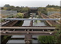
5
Footbridge over Monk's Ditch, Llanwern
The footbridge was built over Monk's Ditch http://www.geograph.org.uk/photo/3635669 during major work in 2012-2013 to transform the private road through Llanwern Steelworks into a public road between Newport and Magor.
The newly opened road has been designated the A4810.
Image: © Jaggery
Taken: 3 Sep 2013
0.19 miles
6
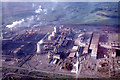
Aerial view to Llanwern Steel Works
Most of this area has now been levelled.
Image: © Colin Park
Taken: 25 Sep 1977
0.20 miles
7
Monk's Ditch south of the A4810, Llanwern
Monk's Ditch is a major channel draining the flat, low-lying Caldicot Level.
It empties into the Mouth of the Severn near Goldcliff.
Here, Monk's Ditch is 10 metres wide in an area that used to be part of a steelworks.
Image: © Jaggery
Taken: 3 Sep 2013
0.22 miles
8
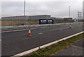
Hot Strip Mill, Llanwern Steelworks
Viewed from the A4810 past boards showing ST MODWEN THE UK'S LEADING REGENERATION SPECIALIST. Now owned by Tata, Llanwern Steelworks operates in a site much reduced from its original size. The A4810, previously known as Queen's Way, used to be a private road through the steelworks. Now it is a recently-upgraded public road from Newport to Magor.
Image: © Jaggery
Taken: 3 Sep 2013
0.22 miles
9

Bend in overhead pipeline, Llanwern Steelworks
Viewed across the A4810.
Image: © Jaggery
Taken: 3 Sep 2013
0.22 miles