IMAGES TAKEN NEAR TO
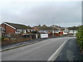
Moorland Gardens, NEWPORT, NP19 4PY
Introduction
This page details the photographs taken nearby to Moorland Gardens, NP19 4PY by members of the Geograph project.
The Geograph project started in 2005 with the aim of publishing, organising and preserving representative images for every square kilometre of Great Britain, Ireland and the Isle of Man.

There are currently over 7.5m images from over14,400 individuals and you can help contribute to the project by visiting https://www.geograph.org.uk
Image Map
Images are licensed for reuse under creativecommons.org/licenses/by-sa/2.0
Notes
- Clicking on the map will re-center to the selected point.
- The higher the marker number, the further away the image location is from the centre of the postcode.
Image Listing (146 Images Found)
Images are licensed for reuse under creativecommons.org/licenses/by-sa/2.0
Image
Details
Distance
1

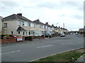
Greenmeadow Avenue, Newport
Houses on the north side of the avenue, viewed from near the corner of Greenmeadow Road. In the distance is the junction with Moorland Avenue. http://www.geograph.org.uk/photo/2141491
Image: © Jaggery
Taken: 2 Nov 2010
0.02 miles
2
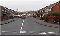
Moorland Avenue, Newport
Semi-detached houses on the east side of the avenue, viewed from Liswerry Road.
Image: © Jaggery
Taken: 10 Aug 2011
0.02 miles
3
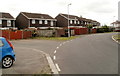
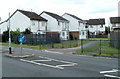
Houses on a bend in Moorland Park, Newport
The houses are near the western edge of Moorland Park, a 1960s housing estate on the north side of Broadmead Park.
Image: © Jaggery
Taken: 10 Aug 2011
0.04 miles
4
Greenmeadow Avenue, Liswerry, Newport
Viewed from Greenmeadow Road looking towards Moorland Avenue. Signs with white arrows
on a blue background indicate a one-way traffic system, away from the camera.
Image: © Jaggery
Taken: 5 May 2014
0.06 miles
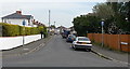
5
Greenmeadow Road, Liswerry, Newport
Looking south from Liswerry Road.
Image: © Jaggery
Taken: 5 Jul 2016
0.06 miles
6
Northern corner of Eastmoor Road, Newport
Eastmoor Road follows a course roughly similar to an inverted V, on the north side of Pontfaen Road. Seen here are bungalows adjacent to the sharp bend at the point of the V.
Image: © Jaggery
Taken: 2 Nov 2010
0.06 miles
7

Liswerry Pill Reen, Newport
Viewed from Greenmeadow Road. The path alongside the reen (drainage channel) heads towards Moorland Park and Broadmead Park.
Image: © Jaggery
Taken: 2 Nov 2010
0.06 miles
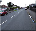
8
Greenmeadow Road, Liswerry, Newport
Looking NNW from Pontfaen Road.
Image: © Jaggery
Taken: 5 May 2014
0.07 miles
9

Moorland Avenue, Newport
Houses on the east side of the avenue, viewed from the corner of Greenmeadow Avenue.
Image: © Jaggery
Taken: 2 Nov 2010
0.08 miles
10
Moorland Park houses opposite Newport East Community Centre
The houses, part of the 205-house Moorland Park estate built in the 1960s, are opposite the community centre. http://www.geograph.org.uk/photo/2547998
Image: © Jaggery
Taken: 10 Aug 2011
0.08 miles