IMAGES TAKEN NEAR TO
Moorland Park, NEWPORT, NP19 4ND
Introduction
This page details the photographs taken nearby to Moorland Park, NP19 4ND by members of the Geograph project.
The Geograph project started in 2005 with the aim of publishing, organising and preserving representative images for every square kilometre of Great Britain, Ireland and the Isle of Man.

There are currently over 7.5m images from over14,400 individuals and you can help contribute to the project by visiting https://www.geograph.org.uk
Image Map
Images are licensed for reuse under creativecommons.org/licenses/by-sa/2.0
Notes
- Clicking on the map will re-center to the selected point.
- The higher the marker number, the further away the image location is from the centre of the postcode.
Image Listing (183 Images Found)
Images are licensed for reuse under creativecommons.org/licenses/by-sa/2.0
Image
Details
Distance
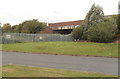
1
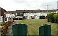
Houses in the NE corner of Moorland Park, Newport
Viewed over the top of a fence, from the perimeter road. I assume the fence is there to prevent children playing on the grassy area from running into the roadway.
Moorland Park is an estate of 205 houses built in the 1960s.
Image: © Jaggery
Taken: 10 Aug 2011
0.03 miles
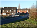
2
Newport : Moorland Park houses viewed from the railway perimeter fence
Moorland Park is an estate of 205 houses built in the 1960s. The several arms or spurs of houses are not separately named. Addresses are from 1 to 205 Moorland Park. This arm is near the NE corner of the estate viewed from the perimeter fence of the South Wales main railway line.
Image: © Jaggery
Taken: 10 Aug 2011
0.03 miles
3
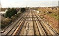
South Wales main line, Spytty Road, Newport
Looking west (towards the centre of Newport) along the South Wales main railway line, from Spytty Road (A455) bridge. Moorland Park is on the left ; Liswerry Park Drive is on the right.
Image: © Jaggery
Taken: 17 Dec 2009
0.04 miles
4
South Wales main line from Spytty Road bridge, Newport
The view is in the direction of Newport railway station from Spytty Road at the NE edge of Moorland Park. Among the differences from the view http://www.geograph.org.uk/photo/1623202 taken a year previously are a new crossover between the middle two tracks, and the appearance of a 40mph speed limit sign on the left.
Image: © Jaggery
Taken: 5 Dec 2010
0.04 miles
5
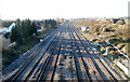
Spytty Road railway bridge viewed from Moorland Park, Newport
Viewed from the NE corner of Moorland Park housing estate. The bridge carries Spytty Road over the South Wales main railway line.
Image: © Jaggery
Taken: 10 Aug 2011
0.04 miles
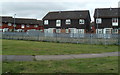
6
Moorland Park houses, Newport
The SE edge of Moorland Park, an estate of 205 houses built in the 1960s, on the west side of Spytty Road (A48). The railings are where the road crosses over Liswerry Pill Reen, a drainage channel marking the border between Moorland Park and Broadmead Park, from where this view was taken.
Image: © Jaggery
Taken: 5 Dec 2010
0.06 miles
7
East side of Broadmead Park, Newport
Viewed from the perimeter road on the east side of a 1960s housing estate containing 236 houses. There are no individually-named streets here : the house addresses are 1-236 Broadmead Park. Number 1 is in the SW corner of the estate and number 236 is in the NE corner.
To the north of Broadmead Park is Moorland Park, a housing estate built at the same time. A drainage channel, Liswerry Pill Reen, http://www.geograph.org.uk/photo/2547813 is the dividing line between the two estates.
Image: © Jaggery
Taken: 10 Aug 2011
0.06 miles
8
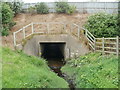
Culvert under Spytty Road, Newport
The culvert conveys Liswerry Pill Reen (drainage channel) under Spytty Road.
Behind the camera, the reen is the boundary http://www.geograph.org.uk/photo/2547813 between Broadmead Park to the south and Moorland Park to the north.
Image: © Jaggery
Taken: 10 Aug 2011
0.06 miles
9
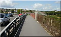
Spytty Road railway bridge, Newport
Looking towards Alway along the pavement on the eastern side of the bridge carrying Spytty Road across the South Wales main line.
Image: © Jaggery
Taken: 20 Aug 2009
0.07 miles
10
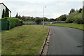
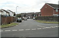
NE corner of Moorland Park, Newport
The road at the eastern edge of Moorland Park turns through 90 degrees ahead, at the edge of the perimeter fence of the South Wales main railway line.
Moorland Park is an estate of 205 houses built in the 1960s.
Image: © Jaggery
Taken: 10 Aug 2011
0.07 miles