IMAGES TAKEN NEAR TO
Thompson Avenue, NEWPORT, NP19 4LT
Introduction
This page details the photographs taken nearby to Thompson Avenue, NP19 4LT by members of the Geograph project.
The Geograph project started in 2005 with the aim of publishing, organising and preserving representative images for every square kilometre of Great Britain, Ireland and the Isle of Man.

There are currently over 7.5m images from over14,400 individuals and you can help contribute to the project by visiting https://www.geograph.org.uk
Image Map
Images are licensed for reuse under creativecommons.org/licenses/by-sa/2.0
Notes
- Clicking on the map will re-center to the selected point.
- The higher the marker number, the further away the image location is from the centre of the postcode.
Image Listing (160 Images Found)
Images are licensed for reuse under creativecommons.org/licenses/by-sa/2.0
Image
Details
Distance
1
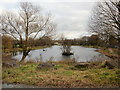
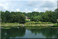
Liswerry Pond from the west
Looking across Liswerry Pond from the west bank. The small eyot (pond island) has a larger counterpart http://www.geograph.org.uk/photo/1589767 at the eastern end of the pond.
Image: © Jaggery
Taken: 28 Jan 2010
0.03 miles
2
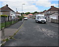
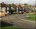
Thompson Avenue, Liswerry, Newport
The southeast end of Thompson Avenue, viewed from the edge of Liswerry Road.
A nearby sign shows that Thompson Avenue leads to Royston Crescent and Thompson Close.
Image: © Jaggery
Taken: 5 Jul 2016
0.03 miles
4
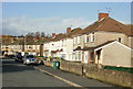
Thompson Avenue, Liswerry, Newport
Houses on the east side of Thompson Avenue, viewed from the Moorland Park end of Liswerry Road.
Image: © Jaggery
Taken: 20 Nov 2009
0.04 miles
5

Lliswerry Pond
Lliswerry pond, Newport.
Image: © Alan Hughes
Taken: 27 Oct 2016
0.04 miles
6
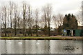
Three swans on Liswerry Pond, Newport
Viewed from the path on the north side of Liswerry Pond. The building on the right
supplies items for anglers. The pond is one of the venues used by the Newport Angling Association. http://www.geograph.org.uk/photo/1589763 to another view of the pond, and a potted history.
Image: © Jaggery
Taken: 28 Jan 2010
0.05 miles
8
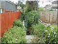
Unnamed reen, Thompson Avenue, Newport
Partly hidden by early August vegetation, a reen (drainage channel) emerges from a culvert carrying it under Thompson Avenue.
Image: © Jaggery
Taken: 10 Aug 2011
0.06 miles
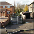
9
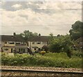
Liswerry Road north of the railway
Split from its southern section by the South Wales main line, Liswerry Road here continues northwards on the north side of the tracks. The view is of houses on the west side of the road, adjacent to Liswerry Park Drive.
Image: © Jaggery
Taken: 20 Nov 2009
0.08 miles
10
Entrance gate to Liswerry Pond, Newport
From Liswerry Road, close to the railway lines. http://www.geograph.org.uk/photo/1589763 to Liswerry Pond
Image: © Jaggery
Taken: 20 Nov 2009
0.08 miles